Larderia geodata
Larderia (Sicily) is a populated place; located in Italy in Europe/Rome (GMT+2) time zone. With population of 2,478 people, there are 3548 cities with bigger population in this country. Compared to other cities in Italy, 95.4% of cities are located further ↑North; 90.6% of cities are located further ←West and 60.3% of cities have higher elevation than Larderia. Note1


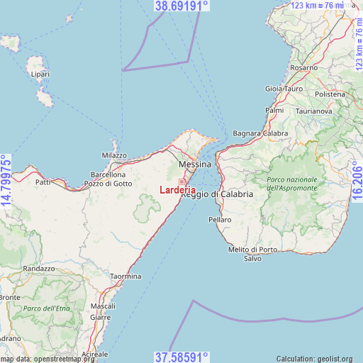
Larderia GPS coordinates[2]
38° 8' 27.636" North, 15° 30' 10.332" East
| Map corner | latitude | longitude |
|---|---|---|
| Upper-left | 38.69191°, | 14.79975° |
| Center: | 38.14101°, | 15.50287° |
| Lower-right: | 37.58591°, | 16.206° |
| Map W x H: | 123×123 km | = 76.4×76.4mi |
| max Lat: | 47.04031° ⇑95.4% North |
| Larderia: | 38.14101° |
| min Lat: | ⇓4.6% South 35.50142° |
| min Long | Larderia | max Long |
| 6.69888° | 15.50287° | 18.48682° |
| W 90.6%⇐ | ⇒9.4% E |
Elevation
Elevation of Larderia is 161 m = 528 ft, and this is 145.7 m = 478 ft below average elevation for this country.
| Max E: |
2085 m = 6841 ft | 60.3% |
| Avg. | 306.7 m = 1006 ft | |
| Larderia | 161 m = 528 ft | |
Min E: |
-4 m = -13 ft | 39.7% |
See also: Italy elevation on elevation.city.
Geographical zone
Larderia is located in North temperate zone (between Tropic of Cancer and the Arctic Circle). Distance of this Northern Tropic circle is 1635 km =1015.9 mi to South.| Distance of | km | miles | from Larderia |
|---|---|---|---|
| North Pole | 5766.2 | 3582.9 | to North |
| Arctic Circle | 3160.3 | 1963.7 | to North |
| Tropic Cancer | 1635 | 1015.9 | to South |
| Equator | 4240.9 | 2635.2 | to South |


Nearby cities:
15 places around Larderia: (largest is in red/bold)
• Gesso
10.9 km =6.8 mi,  344°
344°
• Giampilieri
8.6 km =5.3 mi,  199°
199°
• Guidomandri Marina
11.2 km =7 mi, 198°
• Itala
11.5 km =7.1 mi,  210°
210°
• Messina
7.3 km =4.5 mi,  36°
36°
• Mili San Pietro
2 km =1.2 mi,  217°
217°
• Monforte San Giorgio
10.8 km =6.7 mi,  279°
279°
• Rometta
8.4 km =5.2 mi,  292°
292°
• Salice
12.1 km =7.5 mi,  357°
357°
• San Filippo Superiore
2.7 km =1.7 mi, 356°
• Saponara
8.3 km =5.2 mi,  313°
313°
• Saponara Marittima
12.1 km =7.5 mi,  326°
326°
• Scaletta Zanclea
10.8 km =6.7 mi, 196°
• Scarcelli
9.5 km =5.9 mi,  318°
318°
• Venetico Superiore
12.1 km =7.5 mi,  298°
298°
Sources, notices
• [Note1] Compared only with cities in Italy existing in our database
• [Src1] Map data: © OpenStreetMap contributors (CC-BY-SA)
• [Src2] Other city data from geonames.org with taken over terms of usage.
• [Src3] Geographical zone / Annual Mean Temperature by Robert A. Rohde @ Wikipedia
