Rometta geodata
Rometta (Sicily) is a seat of a third-order administrative division; located in Italy in Europe/Rome (GMT+2) time zone. With population of 867 people, there are 7328 cities with bigger population in this country. Compared to other cities in Italy, 95.2% of cities are located further ↑North; 90.2% of cities are located further ←West and 79.5% of cities have lower elevation than Rometta. Note1


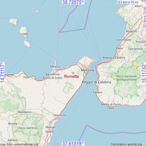
Rometta GPS coordinates[2]
38° 10' 12.252" North, 15° 24' 51.444" East
| Map corner | latitude | longitude |
|---|---|---|
| Upper-left | 38.72075°, | 14.71117° |
| Center: | 38.17007°, | 15.41429° |
| Lower-right: | 37.61519°, | 16.11742° |
| Map W x H: | 122.9×122.9 km | = 76.4×76.4mi |
| max Lat: | 47.04031° ⇑95.2% North |
| Rometta: | 38.17007° |
| min Lat: | ⇓4.8% South 35.50142° |
| min Long | Rometta | max Long |
| 6.69888° | 15.41429° | 18.48682° |
| W 90.2%⇐ | ⇒9.8% E |
Elevation
Elevation of Rometta is 518 m = 1699 ft, and this is 211.3 m = 693 ft above average elevation for this country.
| Max E: |
2085 m = 6841 ft | 20.5% |
| Rometta | 518 m 1699 ft | |
| Avg. | 306.7 m = 1006 ft | |
Min E: |
-4 m = -13 ft | 79.5% |
See also: Italy elevation on elevation.city.
Geographical zone
Rometta is located in North temperate zone (between Tropic of Cancer and the Arctic Circle). Distance of this Northern Tropic circle is 1638.2 km =1017.9 mi to South.| Distance of | km | miles | from Rometta |
|---|---|---|---|
| North Pole | 5762.9 | 3580.9 | to North |
| Arctic Circle | 3157.1 | 1961.7 | to North |
| Tropic Cancer | 1638.2 | 1017.9 | to South |
| Equator | 4244.1 | 2637.2 | to South |


Nearby cities:
15 places around Rometta: (largest is in red/bold)
• Condrò
7.7 km =4.8 mi,  273°
273°
• Fondachello
7.2 km =4.5 mi,  315°
315°
• Monforte San Giorgio
3.2 km =2 mi,  243°
243°
• Roccavaldina
3.8 km =2.4 mi,  292°
292°
• Rometta Marea
7 km =4.3 mi,  356°
356°
• San Filippo Superiore
7.6 km =4.7 mi,  93°
93°
• San Pier Niceto
5.7 km =3.5 mi,  259°
259°
• Saponara
3 km =1.9 mi,  35°
35°
• Saponara Marittima
6.9 km =4.3 mi,  8°
8°
• Scarcelli
4.2 km =2.6 mi,  21°
21°
• Spadafora
6.6 km =4.1 mi,  334°
334°
• Torregrotta
6.7 km =4.2 mi,  302°
302°
• Valdina
4.7 km =2.9 mi, 303°
• Venetico Marina
6.9 km =4.3 mi, 322°
• Venetico Superiore
3.9 km =2.4 mi,  311°
311°
Sources, notices
• [Note1] Compared only with cities in Italy existing in our database
• [Src1] Map data: © OpenStreetMap contributors (CC-BY-SA)
• [Src2] Other city data from geonames.org with taken over terms of usage.
• [Src3] Geographical zone / Annual Mean Temperature by Robert A. Rohde @ Wikipedia
