Saponara geodata
Saponara (Sicily) is a seat of a third-order administrative division; located in Italy in Europe/Rome (GMT+2) time zone. With population of 1,473 people, there are 5187 cities with bigger population in this country. Compared to other cities in Italy, 95.1% of cities are located further ↑North; 90.3% of cities are located further ←West and 60% of cities have higher elevation than Saponara. Note1


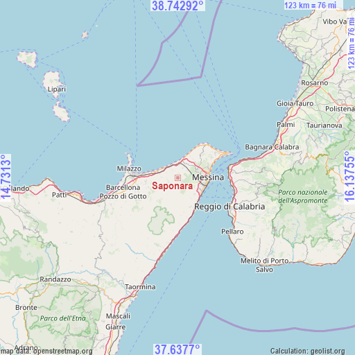
Saponara GPS coordinates[2]
38° 11' 32.676" North, 15° 26' 3.912" East
| Map corner | latitude | longitude |
|---|---|---|
| Upper-left | 38.74292°, | 14.7313° |
| Center: | 38.19241°, | 15.43442° |
| Lower-right: | 37.6377°, | 16.13755° |
| Map W x H: | 122.9×122.9 km | = 76.4×76.4mi |
| max Lat: | 47.04031° ⇑95.1% North |
| Saponara: | 38.19241° |
| min Lat: | ⇓4.9% South 35.50142° |
| min Long | Saponara | max Long |
| 6.69888° | 15.43442° | 18.48682° |
| W 90.3%⇐ | ⇒9.7% E |
Elevation
Elevation of Saponara is 163 m = 535 ft, and this is 143.7 m = 471 ft below average elevation for this country.
| Max E: |
2085 m = 6841 ft | 60% |
| Avg. | 306.7 m = 1006 ft | |
| Saponara | 163 m = 535 ft | |
Min E: |
-4 m = -13 ft | 40% |
See also: Italy elevation on elevation.city.
Geographical zone
Saponara is located in North temperate zone (between Tropic of Cancer and the Arctic Circle). Distance of this Northern Tropic circle is 1640.7 km =1019.5 mi to South.| Distance of | km | miles | from Saponara |
|---|---|---|---|
| North Pole | 5760.5 | 3579.4 | to North |
| Arctic Circle | 3154.6 | 1960.2 | to North |
| Tropic Cancer | 1640.7 | 1019.5 | to South |
| Equator | 4246.6 | 2638.7 | to South |


Nearby cities:
15 places around Saponara: (largest is in red/bold)
• Fondachello
7.3 km =4.5 mi,  291°
291°
• Gesso
5.6 km =3.5 mi,  32°
32°
• Monforte San Giorgio
6.1 km =3.8 mi,  229°
229°
• Roccavaldina
5.4 km =3.4 mi,  258°
258°
• Rometta
3 km =1.9 mi,  215°
215°
• Rometta Marea
5 km =3.1 mi,  334°
334°
• San Filippo Superiore
6.5 km =4 mi,  117°
117°
• Saponara Marittima
4.4 km =2.7 mi,  350°
350°
• Scarcelli
1.5 km =0.9 mi, 350°
• Spadafora
5.8 km =3.6 mi,  306°
306°
• Torregrotta
7.5 km =4.7 mi,  278°
278°
• Valdina
5.6 km =3.5 mi,  271°
271°
• Venetico Marina
6.6 km =4.1 mi,  296°
296°
• Venetico Superiore
4.7 km =2.9 mi, 270°
• Villafranca Tirrena
5.3 km =3.3 mi,  4°
4°
Sources, notices
• [Note1] Compared only with cities in Italy existing in our database
• [Src1] Map data: © OpenStreetMap contributors (CC-BY-SA)
• [Src2] Other city data from geonames.org with taken over terms of usage.
• [Src3] Geographical zone / Annual Mean Temperature by Robert A. Rohde @ Wikipedia
