Gratteri geodata
Gratteri (Sicily) is a seat of a third-order administrative division; located in Italy in Europe/Rome (GMT+2) time zone. With population of 840 people, there are 7445 cities with bigger population in this country. Compared to other cities in Italy, 96.9% of cities are located further ↑North; 78% of cities are located further ←West and 88.7% of cities have lower elevation than Gratteri. Note1


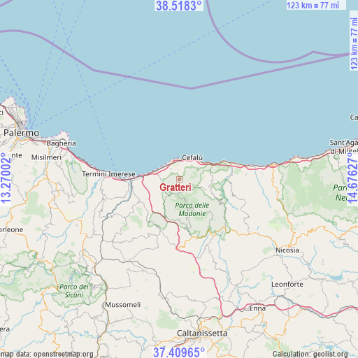
Gratteri GPS coordinates[2]
37° 57' 57.852" North, 13° 58' 23.304" East
| Map corner | latitude | longitude |
|---|---|---|
| Upper-left | 38.5183°, | 13.27002° |
| Center: | 37.96607°, | 13.97314° |
| Lower-right: | 37.40965°, | 14.67627° |
| Map W x H: | 123.3×123.3 km | = 76.6×76.6mi |
| max Lat: | 47.04031° ⇑96.9% North |
| Gratteri: | 37.96607° |
| min Lat: | ⇓3.1% South 35.50142° |
| min Long | Gratteri | max Long |
| 6.69888° | 13.97314° | 18.48682° |
| W 78%⇐ | ⇒22% E |
Elevation
Elevation of Gratteri is 687 m = 2254 ft, and this is 380.3 m = 1248 ft above average elevation for this country.
| Max E: |
2085 m = 6841 ft | 11.3% |
| Gratteri | 687 m 2254 ft | |
| Avg. | 306.7 m = 1006 ft | |
Min E: |
-4 m = -13 ft | 88.7% |
See also: Italy elevation on elevation.city.
Geographical zone
Gratteri is located in North temperate zone (between Tropic of Cancer and the Arctic Circle). Distance of this Northern Tropic circle is 1615.5 km =1003.8 mi to South.| Distance of | km | miles | from Gratteri |
|---|---|---|---|
| North Pole | 5785.6 | 3595 | to North |
| Arctic Circle | 3179.7 | 1975.8 | to North |
| Tropic Cancer | 1615.5 | 1003.8 | to South |
| Equator | 4221.4 | 2623.1 | to South |


Nearby cities:
15 places around Gratteri: (largest is in red/bold)
• Caltavuturo
17.7 km =11 mi,  203°
203°
• Campofelice di Roccella
9 km =5.6 mi,  289°
289°
• Castelbuono
10.9 km =6.8 mi,  114°
114°
• Cefalù
9.2 km =5.7 mi,  28°
28°
• Cerda
15.4 km =9.6 mi,  244°
244°
• Collesano
6.2 km =3.9 mi,  210°
210°
• Finale
17.5 km =10.9 mi,  70°
70°
• Isnello
3.9 km =2.4 mi,  130°
130°
• Lascari
4.8 km =3 mi,  323°
323°
• Piana Calzata
7.5 km =4.7 mi,  304°
304°
• Polizzi Generosa
17.4 km =10.8 mi,  171°
171°
• Pollina
15.4 km =9.6 mi,  78°
78°
• Sciara
19.4 km =12.1 mi,  253°
253°
• Scillato
13.4 km =8.3 mi, 205°
• Sclafani Bagni
19.1 km =11.9 mi, 212°
Sources, notices
• [Note1] Compared only with cities in Italy existing in our database
• [Src1] Map data: © OpenStreetMap contributors (CC-BY-SA)
• [Src2] Other city data from geonames.org with taken over terms of usage.
• [Src3] Geographical zone / Annual Mean Temperature by Robert A. Rohde @ Wikipedia
