Cefalù geodata
Cefalù (Sicily) is a seat of a third-order administrative division; located in Italy in Europe/Rome (GMT+2) time zone. With population of 11,613 people, there are 805 cities with bigger population in this country. Compared to other cities in Italy, 96.2% of cities are located further ↑North; 78.3% of cities are located further ←West and 82% of cities have higher elevation than Cefalù. Note1


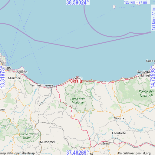
Cefalù GPS coordinates[2]
38° 2' 18.816" North, 14° 1' 22.26" East
| Map corner | latitude | longitude |
|---|---|---|
| Upper-left | 38.59024°, | 13.31973° |
| Center: | 38.03856°, | 14.02285° |
| Lower-right: | 37.48269°, | 14.72598° |
| Map W x H: | 123.1×123.1 km | = 76.5×76.5mi |
| max Lat: | 47.04031° ⇑96.2% North |
| Cefalù: | 38.03856° |
| min Lat: | ⇓3.8% South 35.50142° |
| min Long | Cefalù | max Long |
| 6.69888° | 14.02285° | 18.48682° |
| W 78.3%⇐ | ⇒21.7% E |
Elevation
Elevation of Cefalù is 42 m = 138 ft, and this is 264.7 m = 868 ft below average elevation for this country.
| Max E: |
2085 m = 6841 ft | 82% |
| Avg. | 306.7 m = 1006 ft | |
| Cefalù | 42 m = 138 ft | |
Min E: |
-4 m = -13 ft | 18% |
See also: Italy elevation on elevation.city.
Geographical zone
Cefalù is located in North temperate zone (between Tropic of Cancer and the Arctic Circle). Distance of this Northern Tropic circle is 1623.6 km =1008.9 mi to South.| Distance of | km | miles | from Cefalù |
|---|---|---|---|
| North Pole | 5777.6 | 3590 | to North |
| Arctic Circle | 3171.7 | 1970.8 | to North |
| Tropic Cancer | 1623.6 | 1008.9 | to South |
| Equator | 4229.5 | 2628.1 | to South |


Nearby cities:
15 places around Cefalù: (largest is in red/bold)
• Campofelice di Roccella
13.8 km =8.6 mi,  248°
248°
• Castel di Tusa
20.8 km =12.9 mi,  99°
99°
• Castelbuono
13.8 km =8.6 mi,  156°
156°
• Cerda
23.5 km =14.6 mi,  230°
230°
• Collesano
15.4 km =9.6 mi,  209°
209°
• Finale
12.3 km =7.6 mi, 100°
• Geraci Siculo
23 km =14.3 mi,  150°
150°
• Gratteri
9.2 km =5.7 mi, 208°
• Isnello
10.7 km =6.6 mi,  187°
187°
• Lascari
8.4 km =5.2 mi,  239°
239°
• Piana Calzata
11.2 km =7 mi, 250°
• Pollina
11.9 km =7.4 mi,  115°
115°
• San Mauro Castelverde
20.1 km =12.5 mi,  133°
133°
• Scillato
22.5 km =14 mi, 206°
• Tusa
19.6 km =12.2 mi,  108°
108°
Sources, notices
• [Note1] Compared only with cities in Italy existing in our database
• [Src1] Map data: © OpenStreetMap contributors (CC-BY-SA)
• [Src2] Other city data from geonames.org with taken over terms of usage.
• [Src3] Geographical zone / Annual Mean Temperature by Robert A. Rohde @ Wikipedia
