San Michele di Ganzaria geodata
San Michele di Ganzaria (Sicily) is a seat of a third-order administrative division; located in Italy in Europe/Rome (GMT+2) time zone. With population of 3,311 people, there are 2829 cities with bigger population in this country. Compared to other cities in Italy, 99.4% of cities are located further ↑North; 82% of cities are located further ←West and 75.9% of cities have lower elevation than San Michele di Ganzaria. Note1
Current local time in San Michele di Ganzaria:
09:55 PM, WednesdayDifference from your time zone: hours


San Michele di Ganzaria GPS coordinates[2]
37° 16' 49.512" North, 14° 25' 34.788" East
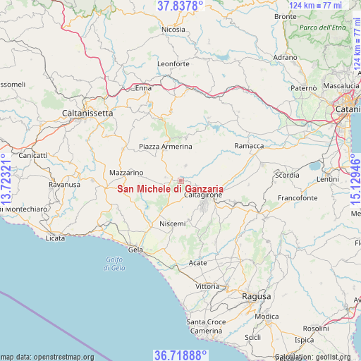
| Map corner | latitude | longitude |
|---|---|---|
| Upper-left | 37.8378°, | 13.72321° |
| Center: | 37.28042°, | 14.42633° |
| Lower-right: | 36.71888°, | 15.12946° |
| Map W x H: | 124.4×124.4 km | = 77.3×77.3mi |
| max Lat: | 47.04031° ⇑99.4% North |
| San Michele di Ganzaria: | 37.28042° |
| min Lat: | ⇓0.6% South 35.50142° |
| min Long | San Michele di | max Long |
| 6.69888° | 14.42633° | 18.48682° |
| W 82%⇐ | ⇒18% E |
Elevation
Elevation of San Michele di Ganzaria is 463 m = 1519 ft, and this is 156.3 m = 513 ft above average elevation for this country.
| Max E: |
2085 m = 6841 ft | 24.1% |
| San Michele di Ganzaria | 463 m 1519 ft | |
| Avg. | 306.7 m = 1006 ft | |
Min E: |
-4 m = -13 ft | 75.9% |
See also: Italy elevation on elevation.city.
Geographical zone
San Michele di Ganzaria is located in North temperate zone (between Tropic of Cancer and the Arctic Circle). Distance of this Northern Tropic circle is 1539.3 km =956.5 mi to South.| Distance of | km | miles | from San Michele di Ganzaria |
|---|---|---|---|
| North Pole | 5861.9 | 3642.4 | to North |
| Arctic Circle | 3256 | 2023.2 | to North |
| Tropic Cancer | 1539.3 | 956.5 | to South |
| Equator | 4145.2 | 2575.7 | to South |


Nearby cities:
15 places around San Michele di Ganzaria: (largest is in red/bold)
• Aidone
15 km =9.3 mi,  6°
6°
• Barrafranca
22.6 km =14 mi,  298°
298°
• Butera
23.8 km =14.8 mi,  245°
245°
• Caltagirone
9.2 km =5.7 mi,  120°
120°
• Grammichele
19.8 km =12.3 mi,  112°
112°
• Mazzarino
19.3 km =12 mi,  277°
277°
• Mazzarrone
24.5 km =15.2 mi,  150°
150°
• Mineo
23.7 km =14.7 mi,  94°
94°
• Mirabella Imbaccari
5.5 km =3.4 mi,  18°
18°
• Niscemi
15.2 km =9.4 mi,  190°
190°
• Piazza Armerina
12.6 km =7.8 mi,  336°
336°
• Raddusa
23.7 km =14.7 mi, 23°
• Ramacca
26.3 km =16.3 mi,  63°
63°
• San Cono
5.3 km =3.3 mi, 281°
• Valguarnera Caropepe
24.1 km =15 mi,  352°
352°
Sources, notices
• [Note1] Compared only with cities in Italy existing in our database
• [Src1] Map data: © OpenStreetMap contributors (CC-BY-SA)
• [Src2] Other city data from geonames.org with taken over terms of usage.
• [Src3] Geographical zone / Annual Mean Temperature by Robert A. Rohde @ Wikipedia
