Camastra geodata
Camastra (Sicily) is a seat of a third-order administrative division; located in Italy in Europe/Rome (GMT+2) time zone. With population of 2,090 people, there are 4003 cities with bigger population in this country. Compared to other cities in Italy, 99.4% of cities are located further ↑North; 76.5% of cities are located further ←West and 65.6% of cities have lower elevation than Camastra. Note1


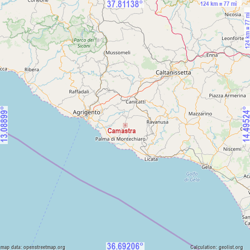
Camastra GPS coordinates[2]
37° 15' 13.68" North, 13° 47' 31.596" East
| Map corner | latitude | longitude |
|---|---|---|
| Upper-left | 37.81138°, | 13.08899° |
| Center: | 37.2538°, | 13.79211° |
| Lower-right: | 36.69206°, | 14.49524° |
| Map W x H: | 124.5×124.5 km | = 77.4×77.4mi |
| max Lat: | 47.04031° ⇑99.4% North |
| Camastra: | 37.2538° |
| min Lat: | ⇓0.6% South 35.50142° |
| min Long | Camastra | max Long |
| 6.69888° | 13.79211° | 18.48682° |
| W 76.5%⇐ | ⇒23.5% E |
Elevation
Elevation of Camastra is 349 m = 1145 ft, and this is 42.3 m = 139 ft above average elevation for this country.
| Max E: |
2085 m = 6841 ft | 34.4% |
| Camastra | 349 m 1145 ft | |
| Avg. | 306.7 m = 1006 ft | |
Min E: |
-4 m = -13 ft | 65.6% |
See also: Italy elevation on elevation.city.
Geographical zone
Camastra is located in North temperate zone (between Tropic of Cancer and the Arctic Circle). Distance of this Northern Tropic circle is 1536.3 km =954.6 mi to South.| Distance of | km | miles | from Camastra |
|---|---|---|---|
| North Pole | 5864.8 | 3644.2 | to North |
| Arctic Circle | 3258.9 | 2025 | to North |
| Tropic Cancer | 1536.3 | 954.6 | to South |
| Equator | 4142.2 | 2573.8 | to South |


Nearby cities:
15 places around Camastra: (largest is in red/bold)
• Agrigento
20.1 km =12.5 mi,  288°
288°
• Campobello di Licata
11.2 km =7 mi,  87°
87°
• Canicattì
12.6 km =7.8 mi,  22°
22°
• Castrofilippo
11.4 km =7.1 mi,  340°
340°
• Delia
16.7 km =10.4 mi,  46°
46°
• Favara
13.5 km =8.4 mi,  301°
301°
• Grotte
18.6 km =11.6 mi,  333°
333°
• Licata
21.3 km =13.2 mi,  142°
142°
• Naro
4.3 km =2.7 mi,  1°
1°
• Palma di Montechiaro
7.4 km =4.6 mi,  198°
198°
• Racalmuto
17.7 km =11 mi, 341°
• Ravanusa
15.7 km =9.8 mi,  84°
84°
• San Leone Mosè
18.4 km =11.4 mi,  273°
273°
• Sommatino
20.3 km =12.6 mi,  63°
63°
• Villaseta
21.2 km =13.2 mi,  283°
283°
Sources, notices
• [Note1] Compared only with cities in Italy existing in our database
• [Src1] Map data: © OpenStreetMap contributors (CC-BY-SA)
• [Src2] Other city data from geonames.org with taken over terms of usage.
• [Src3] Geographical zone / Annual Mean Temperature by Robert A. Rohde @ Wikipedia
