Falerna geodata
Falerna (Calabria) is a seat of a third-order administrative division; located in Italy in Europe/Rome (GMT+2) time zone. With population of 988 people, there are 6718 cities with bigger population in this country. Compared to other cities in Italy, 92.6% of cities are located further ↑North; 94.2% of cities are located further ←West and 83.8% of cities have lower elevation than Falerna. Note1


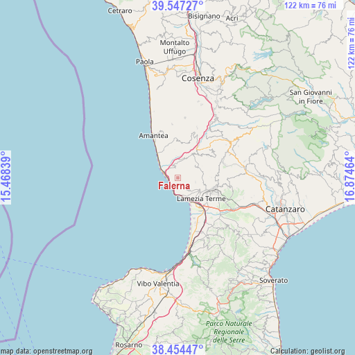
Falerna GPS coordinates[2]
39° 0' 10.728" North, 16° 10' 17.436" East
| Map corner | latitude | longitude |
|---|---|---|
| Upper-left | 39.54727°, | 15.46839° |
| Center: | 39.00298°, | 16.17151° |
| Lower-right: | 38.45447°, | 16.87464° |
| Map W x H: | 121.5×121.5 km | = 75.5×75.5mi |
| max Lat: | 47.04031° ⇑92.6% North |
| Falerna: | 39.00298° |
| min Lat: | ⇓7.4% South 35.50142° |
| min Long | Falerna | max Long |
| 6.69888° | 16.17151° | 18.48682° |
| W 94.2%⇐ | ⇒5.8% E |
Elevation
Elevation of Falerna is 588 m = 1929 ft, and this is 281.3 m = 923 ft above average elevation for this country.
| Max E: |
2085 m = 6841 ft | 16.2% |
| Falerna | 588 m 1929 ft | |
| Avg. | 306.7 m = 1006 ft | |
Min E: |
-4 m = -13 ft | 83.8% |
See also: Italy elevation on elevation.city.
Geographical zone
Falerna is located in North temperate zone (between Tropic of Cancer and the Arctic Circle). Distance of this Northern Tropic circle is 1730.8 km =1075.5 mi to South.| Distance of | km | miles | from Falerna |
|---|---|---|---|
| North Pole | 5670.3 | 3523.4 | to North |
| Arctic Circle | 3064.4 | 1904.1 | to North |
| Tropic Cancer | 1730.8 | 1075.5 | to South |
| Equator | 4336.7 | 2694.7 | to South |


Nearby cities:
15 places around Falerna: (largest is in red/bold)
• Campora San Giovanni
9.8 km =6.1 mi,  317°
317°
• Cleto
9.8 km =6.1 mi,  353°
353°
• Corica
11.6 km =7.2 mi, 321°
• Falerna Scalo
3.7 km =2.3 mi,  205°
205°
• Gizzeria
4 km =2.5 mi,  129°
129°
• Marinella
9.6 km =6 mi,  152°
152°
• Martirano
10.9 km =6.8 mi,  37°
37°
• Martirano Lombardo
9.5 km =5.9 mi,  33°
33°
• Mortilla
7.6 km =4.7 mi, 153°
• Nocera Scalo
4.6 km =2.9 mi,  287°
287°
• Nocera Terinese
3.5 km =2.2 mi, 354°
• Sambiase
10.5 km =6.5 mi,  112°
112°
• San Mango d'Aquino
6.6 km =4.1 mi,  15°
15°
• Santa Eufemia Lamezia
11.6 km =7.2 mi,  142°
142°
• Serra d'Aiello
10.4 km =6.5 mi,  337°
337°
Sources, notices
• [Note1] Compared only with cities in Italy existing in our database
• [Src1] Map data: © OpenStreetMap contributors (CC-BY-SA)
• [Src2] Other city data from geonames.org with taken over terms of usage.
• [Src3] Geographical zone / Annual Mean Temperature by Robert A. Rohde @ Wikipedia
