Marinella geodata
Marinella (Calabria) is a populated place; located in Italy in Europe/Rome (GMT+2) time zone. With population of 644 people, there are 8680 cities with bigger population in this country. Compared to other cities in Italy, 92.9% of cities are located further ↑North; 94.6% of cities are located further ←West and 96.6% of cities have higher elevation than Marinella. Note1
Administrative division(s):
- Level 1: Calabria
- Level 2: Provincia di Catanzaro
- Level 3: Lamezia Terme


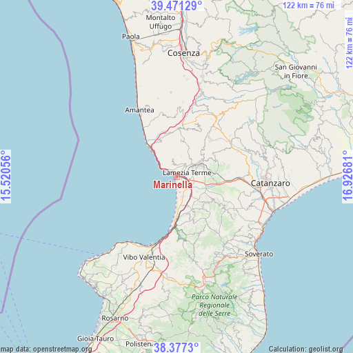
Marinella GPS coordinates[2]
38° 55' 35.04" North, 16° 13' 25.248" East
| Map corner | latitude | longitude |
|---|---|---|
| Upper-left | 39.47129°, | 15.52056° |
| Center: | 38.9264°, | 16.22368° |
| Lower-right: | 38.3773°, | 16.92681° |
| Map W x H: | 121.6×121.6 km | = 75.6×75.6mi |
| max Lat: | 47.04031° ⇑92.9% North |
| Marinella: | 38.9264° |
| min Lat: | ⇓7.1% South 35.50142° |
| min Long | Marinella | max Long |
| 6.69888° | 16.22368° | 18.48682° |
| W 94.6%⇐ | ⇒5.4% E |
Elevation
Elevation of Marinella is 6 m = 20 ft, and this is 300.7 m = 987 ft below average elevation for this country.
| Max E: |
2085 m = 6841 ft | 96.6% |
| Avg. | 306.7 m = 1006 ft | |
| Marinella | 6 m = 20 ft | |
Min E: |
-4 m = -13 ft | 3.4% |
See also: Italy elevation on elevation.city.
Geographical zone
Marinella is located in North temperate zone (between Tropic of Cancer and the Arctic Circle). Distance of this Northern Tropic circle is 1722.3 km =1070.2 mi to South.| Distance of | km | miles | from Marinella |
|---|---|---|---|
| North Pole | 5678.9 | 3528.7 | to North |
| Arctic Circle | 3073 | 1909.5 | to North |
| Tropic Cancer | 1722.3 | 1070.2 | to South |
| Equator | 4328.2 | 2689.4 | to South |


Nearby cities:
15 places around Marinella: (largest is in red/bold)
• Acconia
10.7 km =6.6 mi,  160°
160°
• Curinga
13.4 km =8.3 mi,  144°
144°
• Falerna
9.6 km =6 mi,  332°
332°
• Falerna Scalo
8 km =5 mi,  310°
310°
• Fronti
12.4 km =7.7 mi,  60°
60°
• Gizzeria
6.2 km =3.9 mi,  346°
346°
• Lamezia Terme
8.4 km =5.2 mi, 61°
• Magolà
10.8 km =6.7 mi, 58°
• Mortilla
2.1 km =1.3 mi, 326°
• Nicastro
9.2 km =5.7 mi, 57°
• Nocera Terinese
13 km =8.1 mi,  337°
337°
• Platania
12.3 km =7.6 mi,  43°
43°
• Sambiase
6.8 km =4.2 mi,  49°
49°
• San Pietro a Maida
13.4 km =8.3 mi,  130°
130°
• Santa Eufemia Lamezia
2.6 km =1.6 mi,  106°
106°
Sources, notices
• [Note1] Compared only with cities in Italy existing in our database
• [Src1] Map data: © OpenStreetMap contributors (CC-BY-SA)
• [Src2] Other city data from geonames.org with taken over terms of usage.
• [Src3] Geographical zone / Annual Mean Temperature by Robert A. Rohde @ Wikipedia
