Corica geodata
Corica (Calabria) is a populated place; located in Italy in Europe/Rome (GMT+2) time zone. With population of 665 people, there are 8527 cities with bigger population in this country. Compared to other cities in Italy, 92.3% of cities are located further ↑North; 93.4% of cities are located further ←West and 95.9% of cities have higher elevation than Corica. Note1


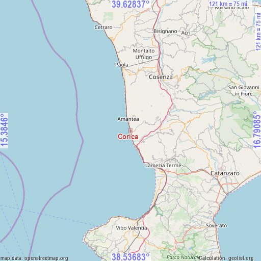
Corica GPS coordinates[2]
39° 5' 4.956" North, 16° 5' 15.792" East
| Map corner | latitude | longitude |
|---|---|---|
| Upper-left | 39.62837°, | 15.3846° |
| Center: | 39.08471°, | 16.08772° |
| Lower-right: | 38.53683°, | 16.79085° |
| Map W x H: | 121.4×121.4 km | = 75.4×75.4mi |
| max Lat: | 47.04031° ⇑92.3% North |
| Corica: | 39.08471° |
| min Lat: | ⇓7.7% South 35.50142° |
| min Long | Corica | max Long |
| 6.69888° | 16.08772° | 18.48682° |
| W 93.4%⇐ | ⇒6.6% E |
Elevation
Elevation of Corica is 7 m = 23 ft, and this is 299.7 m = 983 ft below average elevation for this country.
| Max E: |
2085 m = 6841 ft | 95.9% |
| Avg. | 306.7 m = 1006 ft | |
| Corica | 7 m = 23 ft | |
Min E: |
-4 m = -13 ft | 4.1% |
See also: Italy elevation on elevation.city.
Geographical zone
Corica is located in North temperate zone (between Tropic of Cancer and the Arctic Circle). Distance of this Northern Tropic circle is 1739.9 km =1081.1 mi to South.| Distance of | km | miles | from Corica |
|---|---|---|---|
| North Pole | 5661.2 | 3517.7 | to North |
| Arctic Circle | 3055.4 | 1898.5 | to North |
| Tropic Cancer | 1739.9 | 1081.1 | to South |
| Equator | 4345.8 | 2700.4 | to South |


Nearby cities:
15 places around Corica: (largest is in red/bold)
• Aiello Calabro
7.6 km =4.7 mi,  61°
61°
• Amantea
4.8 km =3 mi,  346°
346°
• Belmonte Calabro
8.8 km =5.5 mi,  356°
356°
• Campora San Giovanni
2 km =1.2 mi,  159°
159°
• Cleto
6.1 km =3.8 mi,  84°
84°
• Falerna
11.6 km =7.2 mi,  141°
141°
• Falerna Scalo
13.7 km =8.5 mi, 155°
• Lago
10.9 km =6.8 mi,  28°
28°
• Marina
9 km =5.6 mi, 347°
• Martirano Lombardo
12.5 km =7.8 mi,  95°
95°
• Nocera Scalo
8.2 km =5.1 mi, 159°
• Nocera Terinese
8.8 km =5.5 mi,  128°
128°
• San Mango d'Aquino
9.4 km =5.8 mi,  106°
106°
• San Pietro in Amantea
6.1 km =3.8 mi,  20°
20°
• Serra d'Aiello
3.4 km =2.1 mi, 79°
Sources, notices
• [Note1] Compared only with cities in Italy existing in our database
• [Src1] Map data: © OpenStreetMap contributors (CC-BY-SA)
• [Src2] Other city data from geonames.org with taken over terms of usage.
• [Src3] Geographical zone / Annual Mean Temperature by Robert A. Rohde @ Wikipedia
