Chiesanuova geodata
Chiesanuova (Sicily) is a populated place; located in Italy in Europe/Rome (GMT+2) time zone. With population of 534 people, there are 9605 cities with bigger population in this country. Compared to other cities in Italy, 96.5% of cities are located further ↑North; 64.3% of cities are located further ←West and 65.8% of cities have higher elevation than Chiesanuova. Note1


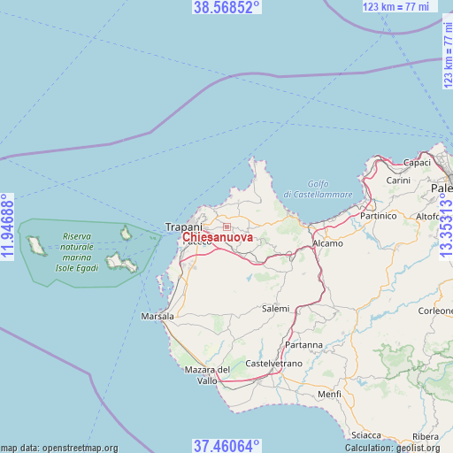
Chiesanuova GPS coordinates[2]
38° 1' 0.012" North, 12° 39' 0" East
| Map corner | latitude | longitude |
|---|---|---|
| Upper-left | 38.56852°, | 11.94688° |
| Center: | 38.01667°, | 12.65° |
| Lower-right: | 37.46064°, | 13.35313° |
| Map W x H: | 123.2×123.2 km | = 76.6×76.6mi |
| max Lat: | 47.04031° ⇑96.5% North |
| Chiesanuova: | 38.01667° |
| min Lat: | ⇓3.5% South 35.50142° |
| min Long | Chiesanuova | max Long |
| 6.69888° | 12.65° | 18.48682° |
| W 64.3%⇐ | ⇒35.7% E |
Elevation
Elevation of Chiesanuova is 123 m = 404 ft, and this is 183.7 m = 603 ft below average elevation for this country.
| Max E: |
2085 m = 6841 ft | 65.8% |
| Avg. | 306.7 m = 1006 ft | |
| Chiesanuova | 123 m = 404 ft | |
Min E: |
-4 m = -13 ft | 34.2% |
See also: Italy elevation on elevation.city.
Geographical zone
Chiesanuova is located in North temperate zone (between Tropic of Cancer and the Arctic Circle). Distance of this Northern Tropic circle is 1621.1 km =1007.3 mi to South.| Distance of | km | miles | from Chiesanuova |
|---|---|---|---|
| North Pole | 5780 | 3591.5 | to North |
| Arctic Circle | 3174.1 | 1972.3 | to North |
| Tropic Cancer | 1621.1 | 1007.3 | to South |
| Equator | 4227.1 | 2626.6 | to South |


Nearby cities:
15 places around Chiesanuova: (largest is in red/bold)
• Buseto Palizzolo
5.4 km =3.4 mi,  105°
105°
• Casa Santa
8.9 km =5.5 mi,  276°
276°
• Castelluzzo
12 km =7.5 mi,  38°
38°
• Crocevie
2.2 km =1.4 mi,  9°
9°
• Custonaci
7.6 km =4.7 mi,  24°
24°
• Erice
5.9 km =3.7 mi,  293°
293°
• Fulgatore-Torretta
8.3 km =5.2 mi,  153°
153°
• Napola
3.3 km =2.1 mi,  208°
208°
• Paceco
9 km =5.6 mi,  243°
243°
• Pizzolungo
8.9 km =5.5 mi,  303°
303°
• Rigaletta
6 km =3.7 mi,  266°
266°
• Sant'Andrea Bonagia
6.1 km =3.8 mi,  331°
331°
• Tonnara di Bonagia
7.1 km =4.4 mi,  316°
316°
• Trapani
10 km =6.2 mi, 270°
• Valderice
4 km =2.5 mi,  310°
310°
Sources, notices
• [Note1] Compared only with cities in Italy existing in our database
• [Src1] Map data: © OpenStreetMap contributors (CC-BY-SA)
• [Src2] Other city data from geonames.org with taken over terms of usage.
• [Src3] Geographical zone / Annual Mean Temperature by Robert A. Rohde @ Wikipedia
