Valderice geodata
Valderice (Sicily) is a seat of a third-order administrative division; located in Italy in Europe/Rome (GMT+2) time zone. With population of 6,827 people, there are 1428 cities with bigger population in this country. Compared to other cities in Italy, 96.2% of cities are located further ↑North; 63.8% of cities are located further ←West and 54.7% of cities have lower elevation than Valderice. Note1


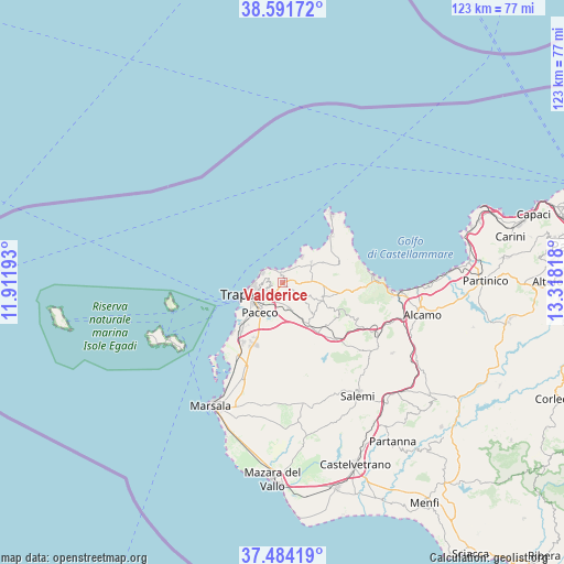
Valderice GPS coordinates[2]
38° 2' 24.18" North, 12° 36' 54.18" East
| Map corner | latitude | longitude |
|---|---|---|
| Upper-left | 38.59172°, | 11.91193° |
| Center: | 38.04005°, | 12.61505° |
| Lower-right: | 37.48419°, | 13.31818° |
| Map W x H: | 123.1×123.1 km | = 76.5×76.5mi |
| max Lat: | 47.04031° ⇑96.2% North |
| Valderice: | 38.04005° |
| min Lat: | ⇓3.8% South 35.50142° |
| min Long | Valderice | max Long |
| 6.69888° | 12.61505° | 18.48682° |
| W 63.8%⇐ | ⇒36.2% E |
Elevation
Elevation of Valderice is 264 m = 866 ft, and this is 42.7 m = 140 ft below average elevation for this country.
| Max E: |
2085 m = 6841 ft | 45.3% |
| Avg. | 306.7 m = 1006 ft | |
| Valderice | 264 m = 866 ft | |
Min E: |
-4 m = -13 ft | 54.7% |
See also: Italy elevation on elevation.city.
Geographical zone
Valderice is located in North temperate zone (between Tropic of Cancer and the Arctic Circle). Distance of this Northern Tropic circle is 1623.7 km =1008.9 mi to South.| Distance of | km | miles | from Valderice |
|---|---|---|---|
| North Pole | 5777.4 | 3589.9 | to North |
| Arctic Circle | 3171.5 | 1970.7 | to North |
| Tropic Cancer | 1623.7 | 1008.9 | to South |
| Equator | 4229.7 | 2628.2 | to South |


Nearby cities:
15 places around Valderice: (largest is in red/bold)
• Buseto Palizzolo
9.2 km =5.7 mi,  116°
116°
• Casa Santa
6.1 km =3.8 mi,  254°
254°
• Chiesanuova
4 km =2.5 mi,  130°
130°
• Crocevie
3.4 km =2.1 mi,  97°
97°
• Custonaci
7.6 km =4.7 mi,  54°
54°
• Erice
2.4 km =1.5 mi,  264°
264°
• Fulgatore-Torretta
12.1 km =7.5 mi,  145°
145°
• Napola
5.7 km =3.5 mi,  165°
165°
• Nubia
11.3 km =7 mi,  232°
232°
• Paceco
8.3 km =5.2 mi,  217°
217°
• Pizzolungo
5 km =3.1 mi,  297°
297°
• Rigaletta
4.2 km =2.6 mi, 224°
• Sant'Andrea Bonagia
2.8 km =1.7 mi,  1°
1°
• Tonnara di Bonagia
3.1 km =1.9 mi,  324°
324°
• Trapani
7.3 km =4.5 mi, 250°
Sources, notices
• [Note1] Compared only with cities in Italy existing in our database
• [Src1] Map data: © OpenStreetMap contributors (CC-BY-SA)
• [Src2] Other city data from geonames.org with taken over terms of usage.
• [Src3] Geographical zone / Annual Mean Temperature by Robert A. Rohde @ Wikipedia
