Castell'Umberto geodata
Castell'Umberto (Sicily) is a seat of a third-order administrative division; located in Italy in Europe/Rome (GMT+2) time zone. With population of 1,288 people, there are 5671 cities with bigger population in this country. Compared to other cities in Italy, 95.8% of cities are located further ↑North; 85.5% of cities are located further ←West and 86.7% of cities have lower elevation than Castell'Umberto. Note1


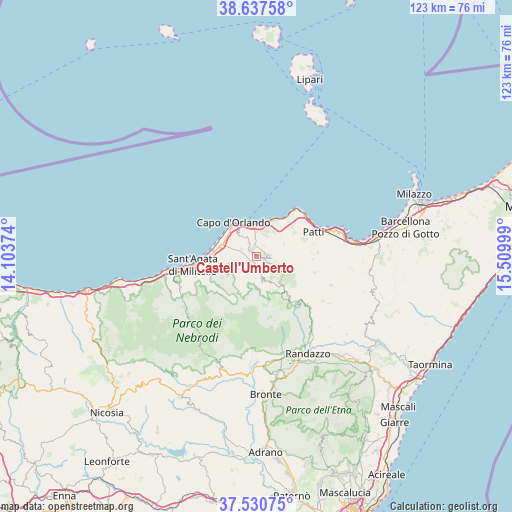
Castell'Umberto GPS coordinates[2]
38° 5' 10.536" North, 14° 48' 24.696" East
| Map corner | latitude | longitude |
|---|---|---|
| Upper-left | 38.63758°, | 14.10374° |
| Center: | 38.08626°, | 14.80686° |
| Lower-right: | 37.53075°, | 15.50999° |
| Map W x H: | 123.1×123.1 km | = 76.5×76.5mi |
| max Lat: | 47.04031° ⇑95.8% North |
| Castell'Umberto: | 38.08626° |
| min Lat: | ⇓4.2% South 35.50142° |
| min Long | Castell'Umberto | max Long |
| 6.69888° | 14.80686° | 18.48682° |
| W 85.5%⇐ | ⇒14.5% E |
Elevation
Elevation of Castell'Umberto is 646 m = 2119 ft, and this is 339.3 m = 1113 ft above average elevation for this country.
| Max E: |
2085 m = 6841 ft | 13.3% |
| Castell'Umberto | 646 m 2119 ft | |
| Avg. | 306.7 m = 1006 ft | |
Min E: |
-4 m = -13 ft | 86.7% |
See also: Italy elevation on elevation.city.
Geographical zone
Castell'Umberto is located in North temperate zone (between Tropic of Cancer and the Arctic Circle). Distance of this Northern Tropic circle is 1628.9 km =1012.2 mi to South.| Distance of | km | miles | from Castell'Umberto |
|---|---|---|---|
| North Pole | 5772.3 | 3586.7 | to North |
| Arctic Circle | 3166.4 | 1967.5 | to North |
| Tropic Cancer | 1628.9 | 1012.2 | to South |
| Equator | 4234.8 | 2631.4 | to South |


Nearby cities:
15 places around Castell'Umberto: (largest is in red/bold)
• Brolo
8 km =5 mi,  13°
13°
• Capri Leone
6.8 km =4.2 mi,  270°
270°
• Cresta
6.3 km =3.9 mi,  325°
325°
• Ficarra
3.2 km =2 mi,  39°
39°
• Frazzanò
5.7 km =3.5 mi,  253°
253°
• Galati Mamertino
6.8 km =4.2 mi,  207°
207°
• Mirto
5.3 km =3.3 mi, 267°
• Naso
4.4 km =2.7 mi,  336°
336°
• San Basilio
8.1 km =5 mi,  197°
197°
• San Salvatore di Fitalia
3.2 km =2 mi,  231°
231°
• Sant'Angelo di Brolo
7.5 km =4.7 mi,  64°
64°
• Sfaranda
3.8 km =2.4 mi,  145°
145°
• Sinagra
3.8 km =2.4 mi,  97°
97°
• Tortorici
6.4 km =4 mi,  168°
168°
• Ucria
7.9 km =4.9 mi,  124°
124°
Sources, notices
• [Note1] Compared only with cities in Italy existing in our database
• [Src1] Map data: © OpenStreetMap contributors (CC-BY-SA)
• [Src2] Other city data from geonames.org with taken over terms of usage.
• [Src3] Geographical zone / Annual Mean Temperature by Robert A. Rohde @ Wikipedia
