Mirto geodata
Mirto (Sicily) is a seat of a third-order administrative division; located in Italy in Europe/Rome (GMT+2) time zone. With population of 874 people, there are 7295 cities with bigger population in this country. Compared to other cities in Italy, 95.8% of cities are located further ↑North; 84.9% of cities are located further ←West and 77.3% of cities have lower elevation than Mirto. Note1


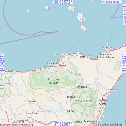
Mirto GPS coordinates[2]
38° 5' 3.804" North, 14° 44' 45.924" East
| Map corner | latitude | longitude |
|---|---|---|
| Upper-left | 38.63572°, | 14.04297° |
| Center: | 38.08439°, | 14.74609° |
| Lower-right: | 37.52887°, | 15.44922° |
| Map W x H: | 123.1×123.1 km | = 76.5×76.5mi |
| max Lat: | 47.04031° ⇑95.8% North |
| Mirto: | 38.08439° |
| min Lat: | ⇓4.2% South 35.50142° |
| min Long | Mirto | max Long |
| 6.69888° | 14.74609° | 18.48682° |
| W 84.9%⇐ | ⇒15.1% E |
Elevation
Elevation of Mirto is 484 m = 1588 ft, and this is 177.3 m = 582 ft above average elevation for this country.
| Max E: |
2085 m = 6841 ft | 22.7% |
| Mirto | 484 m 1588 ft | |
| Avg. | 306.7 m = 1006 ft | |
Min E: |
-4 m = -13 ft | 77.3% |
See also: Italy elevation on elevation.city.
Geographical zone
Mirto is located in North temperate zone (between Tropic of Cancer and the Arctic Circle). Distance of this Northern Tropic circle is 1628.7 km =1012 mi to South.| Distance of | km | miles | from Mirto |
|---|---|---|---|
| North Pole | 5772.5 | 3586.9 | to North |
| Arctic Circle | 3166.6 | 1967.6 | to North |
| Tropic Cancer | 1628.7 | 1012 | to South |
| Equator | 4234.6 | 2631.3 | to South |


Nearby cities:
15 places around Mirto: (largest is in red/bold)
• Capo d'Orlando
6.6 km =4.1 mi,  349°
349°
• Capri Leone
1.5 km =0.9 mi,  280°
280°
• Castell'Umberto
5.3 km =3.3 mi,  87°
87°
• Cresta
5.6 km =3.5 mi,  17°
17°
• Ficarra
7.8 km =4.8 mi,  69°
69°
• Frazzanò
1.4 km =0.9 mi,  187°
187°
• Galati Mamertino
6.3 km =3.9 mi,  159°
159°
• Longi
6.5 km =4 mi,  174°
174°
• Militello Rosmarino
7.5 km =4.7 mi,  235°
235°
• Naso
5.5 km =3.4 mi,  40°
40°
• Rocca di Capri Leone
4 km =2.5 mi,  308°
308°
• San Marco d'Alunzio
4.2 km =2.6 mi,  251°
251°
• San Salvatore di Fitalia
3.3 km =2.1 mi,  122°
122°
• Sfaranda
8 km =5 mi,  111°
111°
• Torrenova
5.9 km =3.7 mi, 278°
Sources, notices
• [Note1] Compared only with cities in Italy existing in our database
• [Src1] Map data: © OpenStreetMap contributors (CC-BY-SA)
• [Src2] Other city data from geonames.org with taken over terms of usage.
• [Src3] Geographical zone / Annual Mean Temperature by Robert A. Rohde @ Wikipedia
