Sfaranda geodata
Sfaranda (Sicily) is a populated place; located in Italy in Europe/Rome (GMT+2) time zone. With population of 1,294 people, there are 5653 cities with bigger population in this country. Compared to other cities in Italy, 96.1% of cities are located further ↑North; 85.8% of cities are located further ←West and 91.4% of cities have lower elevation than Sfaranda. Note1


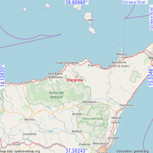
Sfaranda GPS coordinates[2]
38° 3' 29.34" North, 14° 49' 53.292" East
| Map corner | latitude | longitude |
|---|---|---|
| Upper-left | 38.60968°, | 14.12835° |
| Center: | 38.05815°, | 14.83147° |
| Lower-right: | 37.50243°, | 15.5346° |
| Map W x H: | 123.1×123.1 km | = 76.5×76.5mi |
| max Lat: | 47.04031° ⇑96.1% North |
| Sfaranda: | 38.05815° |
| min Lat: | ⇓3.9% South 35.50142° |
| min Long | Sfaranda | max Long |
| 6.69888° | 14.83147° | 18.48682° |
| W 85.8%⇐ | ⇒14.2% E |
Elevation
Elevation of Sfaranda is 753 m = 2470 ft, and this is 446.3 m = 1464 ft above average elevation for this country.
| Max E: |
2085 m = 6841 ft | 8.6% |
| Sfaranda | 753 m 2470 ft | |
| Avg. | 306.7 m = 1006 ft | |
Min E: |
-4 m = -13 ft | 91.4% |
See also: Italy elevation on elevation.city.
Geographical zone
Sfaranda is located in North temperate zone (between Tropic of Cancer and the Arctic Circle). Distance of this Northern Tropic circle is 1625.8 km =1010.2 mi to South.| Distance of | km | miles | from Sfaranda |
|---|---|---|---|
| North Pole | 5775.4 | 3588.7 | to North |
| Arctic Circle | 3169.5 | 1969.4 | to North |
| Tropic Cancer | 1625.8 | 1010.2 | to South |
| Equator | 4231.7 | 2629.5 | to South |


Nearby cities:
15 places around Sfaranda: (largest is in red/bold)
• Capri Leone
9.5 km =5.9 mi,  289°
289°
• Castell'Umberto
3.8 km =2.4 mi,  325°
325°
• Ficarra
5.6 km =3.5 mi,  358°
358°
• Frazzanò
7.8 km =4.8 mi,  281°
281°
• Galati Mamertino
6 km =3.7 mi,  240°
240°
• Longi
7.7 km =4.8 mi, 242°
• Mirto
8 km =5 mi, 291°
• Naso
8.1 km =5 mi, 331°
• Raccuja
6.9 km =4.3 mi,  92°
92°
• San Basilio
6.5 km =4 mi,  225°
225°
• San Salvatore di Fitalia
4.8 km =3 mi, 283°
• Sant'Angelo di Brolo
7.8 km =4.8 mi,  35°
35°
• Sinagra
3.1 km =1.9 mi,  31°
31°
• Tortorici
3.3 km =2.1 mi,  194°
194°
• Ucria
4.5 km =2.8 mi,  107°
107°
Sources, notices
• [Note1] Compared only with cities in Italy existing in our database
• [Src1] Map data: © OpenStreetMap contributors (CC-BY-SA)
• [Src2] Other city data from geonames.org with taken over terms of usage.
• [Src3] Geographical zone / Annual Mean Temperature by Robert A. Rohde @ Wikipedia
