Bocchigliero geodata
Bocchigliero (Calabria) is a seat of a third-order administrative division; located in Italy in Europe/Rome (GMT+2) time zone. With population of 1,474 people, there are 5184 cities with bigger population in this country. Compared to other cities in Italy, 90.7% of cities are located further ↑North; 97.4% of cities are located further ←West and 95.1% of cities have lower elevation than Bocchigliero. Note1


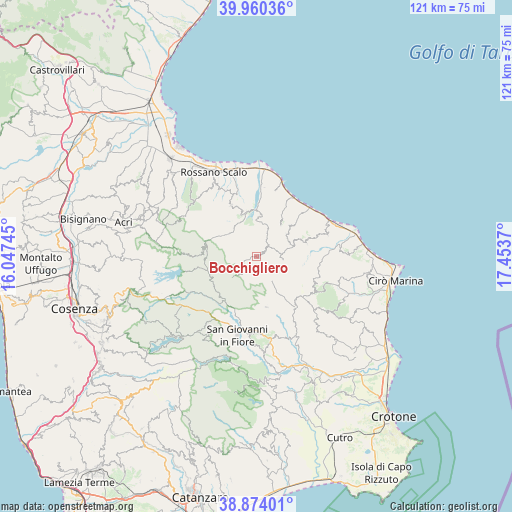
Bocchigliero GPS coordinates[2]
39° 25' 9.48" North, 16° 45' 2.052" East
| Map corner | latitude | longitude |
|---|---|---|
| Upper-left | 39.96036°, | 16.04745° |
| Center: | 39.4193°, | 16.75057° |
| Lower-right: | 38.87401°, | 17.4537° |
| Map W x H: | 120.8×120.8 km | = 75.1×75.1mi |
| max Lat: | 47.04031° ⇑90.7% North |
| Bocchigliero: | 39.4193° |
| min Lat: | ⇓9.3% South 35.50142° |
| min Long | Bocchigliero | max Long |
| 6.69888° | 16.75057° | 18.48682° |
| W 97.4%⇐ | ⇒2.6% E |
Elevation
Elevation of Bocchigliero is 879 m = 2884 ft, and this is 572.3 m = 1878 ft above average elevation for this country.
| Max E: |
2085 m = 6841 ft | 4.9% |
| Bocchigliero | 879 m 2884 ft | |
| Avg. | 306.7 m = 1006 ft | |
Min E: |
-4 m = -13 ft | 95.1% |
See also: Italy elevation on elevation.city.
Geographical zone
Bocchigliero is located in North temperate zone (between Tropic of Cancer and the Arctic Circle). Distance of this Northern Tropic circle is 1777.1 km =1104.2 mi to South.| Distance of | km | miles | from Bocchigliero |
|---|---|---|---|
| North Pole | 5624 | 3494.6 | to North |
| Arctic Circle | 3018.2 | 1875.4 | to North |
| Tropic Cancer | 1777.1 | 1104.2 | to South |
| Equator | 4383 | 2723.5 | to South |


Nearby cities:
15 places around Bocchigliero: (largest is in red/bold)
• Caloppezzati
16.4 km =10.2 mi,  15°
15°
• Caloveto
9.7 km =6 mi,  5°
5°
• Camigliano
16.5 km =10.3 mi,  31°
31°
• Campana
6.2 km =3.9 mi,  95°
95°
• Cropalati
11 km =6.8 mi,  349°
349°
• Crosia
16.7 km =10.4 mi, 6°
• Destro
9.2 km =5.7 mi,  328°
328°
• Longobucco
12.5 km =7.8 mi,  285°
285°
• Mandatoriccio
8.9 km =5.5 mi,  53°
53°
• Paludi
13.7 km =8.5 mi, 333°
• Pietrapaola
9.4 km =5.8 mi,  36°
36°
• Savelli
12.1 km =7.5 mi,  169°
169°
• Scala Coeli
12.1 km =7.5 mi,  74°
74°
• Umbriatico
16.1 km =10 mi,  117°
117°
• Verzino
14.9 km =9.3 mi,  142°
142°
Sources, notices
• [Note1] Compared only with cities in Italy existing in our database
• [Src1] Map data: © OpenStreetMap contributors (CC-BY-SA)
• [Src2] Other city data from geonames.org with taken over terms of usage.
• [Src3] Geographical zone / Annual Mean Temperature by Robert A. Rohde @ Wikipedia
