Verzino geodata
Verzino (Calabria) is a seat of a third-order administrative division; located in Italy in Europe/Rome (GMT+2) time zone. With population of 1,803 people, there are 4483 cities with bigger population in this country. Compared to other cities in Italy, 91.1% of cities are located further ↑North; 97.7% of cities are located further ←West and 83.4% of cities have lower elevation than Verzino. Note1


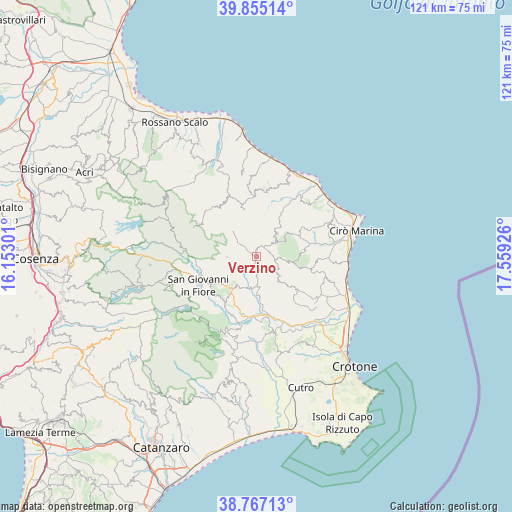
Verzino GPS coordinates[2]
39° 18' 47.7" North, 16° 51' 22.068" East
| Map corner | latitude | longitude |
|---|---|---|
| Upper-left | 39.85514°, | 16.15301° |
| Center: | 39.31325°, | 16.85613° |
| Lower-right: | 38.76713°, | 17.55926° |
| Map W x H: | 121×121 km | = 75.2×75.2mi |
| max Lat: | 47.04031° ⇑91.1% North |
| Verzino: | 39.31325° |
| min Lat: | ⇓8.9% South 35.50142° |
| min Long | Verzino | max Long |
| 6.69888° | 16.85613° | 18.48682° |
| W 97.7%⇐ | ⇒2.3% E |
Elevation
Elevation of Verzino is 578 m = 1896 ft, and this is 271.3 m = 890 ft above average elevation for this country.
| Max E: |
2085 m = 6841 ft | 16.6% |
| Verzino | 578 m 1896 ft | |
| Avg. | 306.7 m = 1006 ft | |
Min E: |
-4 m = -13 ft | 83.4% |
See also: Italy elevation on elevation.city.
Geographical zone
Verzino is located in North temperate zone (between Tropic of Cancer and the Arctic Circle). Distance of this Northern Tropic circle is 1765.3 km =1096.9 mi to South.| Distance of | km | miles | from Verzino |
|---|---|---|---|
| North Pole | 5635.8 | 3501.9 | to North |
| Arctic Circle | 3030 | 1882.8 | to North |
| Tropic Cancer | 1765.3 | 1096.9 | to South |
| Equator | 4371.2 | 2716.1 | to South |


Nearby cities:
15 places around Verzino: (largest is in red/bold)
• Belvedere Spinello
12.2 km =7.6 mi,  165°
165°
• Bocchigliero
14.9 km =9.3 mi,  322°
322°
• Caccuri
11.9 km =7.4 mi,  214°
214°
• Campana
11.5 km =7.1 mi,  345°
345°
• Carfizzi
10.2 km =6.3 mi,  93°
93°
• Casabona
11 km =6.8 mi,  129°
129°
• Castelsilano
9.1 km =5.7 mi,  237°
237°
• Cerenzia
9.6 km =6 mi,  218°
218°
• Melissa
14.9 km =9.3 mi, 91°
• Pallagorio
4.5 km =2.8 mi,  97°
97°
• San Giovanni in Fiore
15.2 km =9.4 mi, 244°
• San Nicola dell'Alto
10.3 km =6.4 mi, 103°
• Savelli
6.9 km =4.3 mi,  269°
269°
• Scala Coeli
15.2 km =9.4 mi,  9°
9°
• Umbriatico
6.9 km =4.3 mi,  50°
50°
Sources, notices
• [Note1] Compared only with cities in Italy existing in our database
• [Src1] Map data: © OpenStreetMap contributors (CC-BY-SA)
• [Src2] Other city data from geonames.org with taken over terms of usage.
• [Src3] Geographical zone / Annual Mean Temperature by Robert A. Rohde @ Wikipedia
