Baucina geodata
Baucina (Sicily) is a seat of a third-order administrative division; located in Italy in Europe/Rome (GMT+2) time zone. With population of 1,887 people, there are 4341 cities with bigger population in this country. Compared to other cities in Italy, 97.2% of cities are located further ↑North; 74% of cities are located further ←West and 82.3% of cities have lower elevation than Baucina. Note1


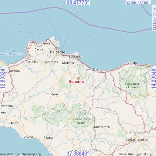
Baucina GPS coordinates[2]
37° 55' 30.756" North, 13° 32' 10.896" East
| Map corner | latitude | longitude |
|---|---|---|
| Upper-left | 38.47775°, | 12.83324° |
| Center: | 37.92521°, | 13.53636° |
| Lower-right: | 37.36849°, | 14.23949° |
| Map W x H: | 123.3×123.3 km | = 76.6×76.6mi |
| max Lat: | 47.04031° ⇑97.2% North |
| Baucina: | 37.92521° |
| min Lat: | ⇓2.8% South 35.50142° |
| min Long | Baucina | max Long |
| 6.69888° | 13.53636° | 18.48682° |
| W 74%⇐ | ⇒26% E |
Elevation
Elevation of Baucina is 559 m = 1834 ft, and this is 252.3 m = 828 ft above average elevation for this country.
| Max E: |
2085 m = 6841 ft | 17.7% |
| Baucina | 559 m 1834 ft | |
| Avg. | 306.7 m = 1006 ft | |
Min E: |
-4 m = -13 ft | 82.3% |
See also: Italy elevation on elevation.city.
Geographical zone
Baucina is located in North temperate zone (between Tropic of Cancer and the Arctic Circle). Distance of this Northern Tropic circle is 1611 km =1001 mi to South.| Distance of | km | miles | from Baucina |
|---|---|---|---|
| North Pole | 5790.2 | 3597.9 | to North |
| Arctic Circle | 3184.3 | 1978.6 | to North |
| Tropic Cancer | 1611 | 1001 | to South |
| Equator | 4216.9 | 2620.3 | to South |


Nearby cities:
15 places around Baucina: (largest is in red/bold)
• Altavilla Milicia
12.6 km =7.8 mi,  5°
5°
• Bolognetta
8.7 km =5.4 mi,  306°
306°
• Caccamo
11.6 km =7.2 mi,  85°
85°
• Campofelice di Fitalia
11.8 km =7.3 mi,  202°
202°
• Casteldaccia
14 km =8.7 mi,  357°
357°
• Cefalà Diana
6.5 km =4 mi,  260°
260°
• Ciminna
3.7 km =2.3 mi,  146°
146°
• Godrano
9.8 km =6.1 mi, 255°
• Marineo
10.8 km =6.7 mi,  285°
285°
• Mezzojuso
9.2 km =5.7 mi,  223°
223°
• Torre Colonna-Sperone
12.1 km =7.5 mi,  15°
15°
• Trabia
12.3 km =7.6 mi,  44°
44°
• Ventimiglia di Sicilia
2.8 km =1.7 mi, 93°
• Vicari
11.6 km =7.2 mi,  165°
165°
• Villafrati
5 km =3.1 mi,  245°
245°
Sources, notices
• [Note1] Compared only with cities in Italy existing in our database
• [Src1] Map data: © OpenStreetMap contributors (CC-BY-SA)
• [Src2] Other city data from geonames.org with taken over terms of usage.
• [Src3] Geographical zone / Annual Mean Temperature by Robert A. Rohde @ Wikipedia
