Baressa geodata
Baressa (Sardinia) is a seat of a third-order administrative division; located in Italy in Europe/Rome (GMT+2) time zone. With population of 723 people, there are 8132 cities with bigger population in this country. Compared to other cities in Italy, 89.4% of cities are located further ↑North; 83.2% of cities are located further →East and 59.9% of cities have higher elevation than Baressa. Note1


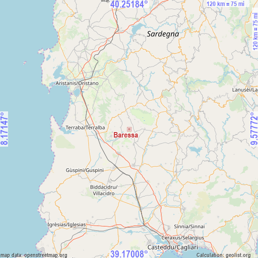
Baressa GPS coordinates[2]
39° 42' 47.088" North, 8° 52' 28.524" East
| Map corner | latitude | longitude |
|---|---|---|
| Upper-left | 40.25184°, | 8.17147° |
| Center: | 39.71308°, | 8.87459° |
| Lower-right: | 39.17008°, | 9.57772° |
| Map W x H: | 120.3×120.3 km | = 74.8×74.8mi |
| max Lat: | 47.04031° ⇑89.4% North |
| Baressa: | 39.71308° |
| min Lat: | ⇓10.6% South 35.50142° |
| min Long | Baressa | max Long |
| 6.69888° | 8.87459° | 18.48682° |
| W 16.8%⇐ | ⇒83.2% E |
Elevation
Elevation of Baressa is 164 m = 538 ft, and this is 142.7 m = 468 ft below average elevation for this country.
| Max E: |
2085 m = 6841 ft | 59.9% |
| Avg. | 306.7 m = 1006 ft | |
| Baressa | 164 m = 538 ft | |
Min E: |
-4 m = -13 ft | 40.1% |
See also: Italy elevation on elevation.city.
Geographical zone
Baressa is located in North temperate zone (between Tropic of Cancer and the Arctic Circle). Distance of this Northern Tropic circle is 1809.8 km =1124.6 mi to South.| Distance of | km | miles | from Baressa |
|---|---|---|---|
| North Pole | 5591.4 | 3474.3 | to North |
| Arctic Circle | 2985.5 | 1855.1 | to North |
| Tropic Cancer | 1809.8 | 1124.6 | to South |
| Equator | 4415.7 | 2743.8 | to South |


Nearby cities:
15 places around Baressa: (largest is in red/bold)
• Baradili
2.2 km =1.4 mi,  63°
63°
• Curcuris
5.2 km =3.2 mi,  315°
315°
• Genuri
5.4 km =3.4 mi,  51°
51°
• Gonnoscodina
3.6 km =2.2 mi,  245°
245°
• Gonnosnò
5.3 km =3.3 mi,  357°
357°
• Gonnostramatza
4.9 km =3 mi,  226°
226°
• Pauli Arbarei
7 km =4.3 mi,  144°
144°
• Pompu
6.8 km =4.2 mi,  281°
281°
• Setzu
5.7 km =3.5 mi,  78°
78°
• Siddi
4.7 km =2.9 mi,  165°
165°
• Simala
4.1 km =2.5 mi, 282°
• Sini
5.2 km =3.2 mi,  29°
29°
• Tuili
7.3 km =4.5 mi,  88°
88°
• Turri
3.7 km =2.3 mi,  104°
104°
• Ussaramanna
3.7 km =2.3 mi,  128°
128°
Sources, notices
• [Note1] Compared only with cities in Italy existing in our database
• [Src1] Map data: © OpenStreetMap contributors (CC-BY-SA)
• [Src2] Other city data from geonames.org with taken over terms of usage.
• [Src3] Geographical zone / Annual Mean Temperature by Robert A. Rohde @ Wikipedia
