Simala geodata
Simala (Sardinia) is a seat of a third-order administrative division; located in Italy in Europe/Rome (GMT+2) time zone. With population of 353 people, there are 10466 cities with bigger population in this country. Compared to other cities in Italy, 89.4% of cities are located further ↑North; 83.8% of cities are located further →East and 62.6% of cities have higher elevation than Simala. Note1


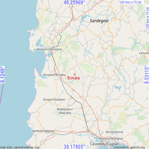
Simala GPS coordinates[2]
39° 43' 15.564" North, 8° 49' 40.872" East
| Map corner | latitude | longitude |
|---|---|---|
| Upper-left | 40.25969°, | 8.1249° |
| Center: | 39.72099°, | 8.82802° |
| Lower-right: | 39.17805°, | 9.53115° |
| Map W x H: | 120.3×120.3 km | = 74.8×74.8mi |
| max Lat: | 47.04031° ⇑89.4% North |
| Simala: | 39.72099° |
| min Lat: | ⇓10.6% South 35.50142° |
| min Long | Simala | max Long |
| 6.69888° | 8.82802° | 18.48682° |
| W 16.2%⇐ | ⇒83.8% E |
Elevation
Elevation of Simala is 144 m = 472 ft, and this is 162.7 m = 534 ft below average elevation for this country.
| Max E: |
2085 m = 6841 ft | 62.6% |
| Avg. | 306.7 m = 1006 ft | |
| Simala | 144 m = 472 ft | |
Min E: |
-4 m = -13 ft | 37.4% |
See also: Italy elevation on elevation.city.
Geographical zone
Simala is located in North temperate zone (between Tropic of Cancer and the Arctic Circle). Distance of this Northern Tropic circle is 1810.6 km =1125.1 mi to South.| Distance of | km | miles | from Simala |
|---|---|---|---|
| North Pole | 5590.5 | 3473.8 | to North |
| Arctic Circle | 2984.6 | 1854.5 | to North |
| Tropic Cancer | 1810.6 | 1125.1 | to South |
| Equator | 4416.6 | 2744.3 | to South |


Nearby cities:
15 places around Simala: (largest is in red/bold)
• Ales
5.4 km =3.4 mi,  348°
348°
• Baradili
5.9 km =3.7 mi,  89°
89°
• Baressa
4.1 km =2.5 mi,  102°
102°
• Curcuris
2.8 km =1.7 mi,  6°
6°
• Gonnoscodina
2.5 km =1.6 mi,  164°
164°
• Gonnosnò
5.8 km =3.6 mi,  39°
39°
• Gonnostramatza
4.2 km =2.6 mi,  174°
174°
• Masullas
4.4 km =2.7 mi,  238°
238°
• Mogoro
6 km =3.7 mi,  227°
227°
• Morgongiori
5.7 km =3.5 mi,  299°
299°
• Pompu
2.7 km =1.7 mi,  279°
279°
• Siddi
7.4 km =4.6 mi,  136°
136°
• Sini
7.5 km =4.7 mi,  61°
61°
• Siris
4.6 km =2.9 mi,  257°
257°
• Ussaramanna
7.6 km =4.7 mi,  114°
114°
Sources, notices
• [Note1] Compared only with cities in Italy existing in our database
• [Src1] Map data: © OpenStreetMap contributors (CC-BY-SA)
• [Src2] Other city data from geonames.org with taken over terms of usage.
• [Src3] Geographical zone / Annual Mean Temperature by Robert A. Rohde @ Wikipedia
