Sini geodata
Sini (Sardinia) is a seat of a third-order administrative division; located in Italy in Europe/Rome (GMT+2) time zone. With population of 510 people, there are 9825 cities with bigger population in this country. Compared to other cities in Italy, 89.2% of cities are located further ↑North; 82.7% of cities are located further →East and 51.4% of cities have lower elevation than Sini. Note1


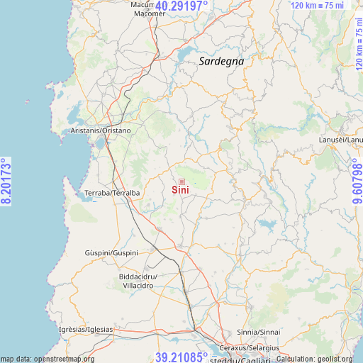
Sini GPS coordinates[2]
39° 45' 12.708" North, 8° 54' 17.496" East
| Map corner | latitude | longitude |
|---|---|---|
| Upper-left | 40.29197°, | 8.20173° |
| Center: | 39.75353°, | 8.90486° |
| Lower-right: | 39.21085°, | 9.60798° |
| Map W x H: | 120.2×120.2 km | = 74.7×74.7mi |
| max Lat: | 47.04031° ⇑89.2% North |
| Sini: | 39.75353° |
| min Lat: | ⇓10.8% South 35.50142° |
| min Long | Sini | max Long |
| 6.69888° | 8.90486° | 18.48682° |
| W 17.3%⇐ | ⇒82.7% E |
Elevation
Elevation of Sini is 243 m = 797 ft, and this is 63.7 m = 209 ft below average elevation for this country.
| Max E: |
2085 m = 6841 ft | 48.6% |
| Avg. | 306.7 m = 1006 ft | |
| Sini | 243 m = 797 ft | |
Min E: |
-4 m = -13 ft | 51.4% |
See also: Italy elevation on elevation.city.
Geographical zone
Sini is located in North temperate zone (between Tropic of Cancer and the Arctic Circle). Distance of this Northern Tropic circle is 1814.3 km =1127.4 mi to South.| Distance of | km | miles | from Sini |
|---|---|---|---|
| North Pole | 5586.9 | 3471.5 | to North |
| Arctic Circle | 2981 | 1852.3 | to North |
| Tropic Cancer | 1814.3 | 1127.4 | to South |
| Equator | 4420.2 | 2746.6 | to South |


Nearby cities:
15 places around Sini: (largest is in red/bold)
• Albagiara
5.3 km =3.3 mi,  315°
315°
• Ales
7.8 km =4.8 mi,  282°
282°
• Assolo
6.3 km =3.9 mi,  11°
11°
• Baradili
3.6 km =2.2 mi,  190°
190°
• Baressa
5.2 km =3.2 mi,  209°
209°
• Curcuris
6.3 km =3.9 mi,  262°
262°
• Genuri
2 km =1.2 mi,  124°
124°
• Gonnosnò
3 km =1.9 mi,  286°
286°
• Senis
8.3 km =5.2 mi,  20°
20°
• Setzu
4.5 km =2.8 mi,  138°
138°
• Simala
7.5 km =4.7 mi,  241°
241°
• Tuili
6.4 km =4 mi,  132°
132°
• Turri
5.5 km =3.4 mi,  169°
169°
• Usellus
7.6 km =4.7 mi, 323°
• Ussaramanna
6.8 km =4.2 mi,  177°
177°
Sources, notices
• [Note1] Compared only with cities in Italy existing in our database
• [Src1] Map data: © OpenStreetMap contributors (CC-BY-SA)
• [Src2] Other city data from geonames.org with taken over terms of usage.
• [Src3] Geographical zone / Annual Mean Temperature by Robert A. Rohde @ Wikipedia
