Amendolara geodata
Amendolara (Calabria) is a seat of a third-order administrative division; located in Italy in Europe/Rome (GMT+2) time zone. With population of 1,270 people, there are 5725 cities with bigger population in this country. Compared to other cities in Italy, 88.3% of cities are located further ↑North; 96.9% of cities are located further ←West and 54.2% of cities have higher elevation than Amendolara. Note1


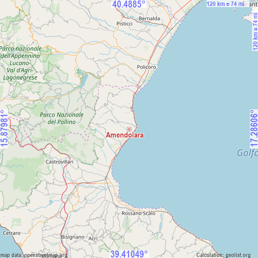
Amendolara GPS coordinates[2]
39° 57' 5.832" North, 16° 34' 58.548" East
| Map corner | latitude | longitude |
|---|---|---|
| Upper-left | 40.4885°, | 15.87981° |
| Center: | 39.95162°, | 16.58293° |
| Lower-right: | 39.41049°, | 17.28606° |
| Map W x H: | 119.9×119.9 km | = 74.5×74.5mi |
| max Lat: | 47.04031° ⇑88.3% North |
| Amendolara: | 39.95162° |
| min Lat: | ⇓11.7% South 35.50142° |
| min Long | Amendolara | max Long |
| 6.69888° | 16.58293° | 18.48682° |
| W 96.9%⇐ | ⇒3.1% E |
Elevation
Elevation of Amendolara is 208 m = 682 ft, and this is 98.7 m = 324 ft below average elevation for this country.
| Max E: |
2085 m = 6841 ft | 54.2% |
| Avg. | 306.7 m = 1006 ft | |
| Amendolara | 208 m = 682 ft | |
Min E: |
-4 m = -13 ft | 45.8% |
See also: Italy elevation on elevation.city.
Geographical zone
Amendolara is located in North temperate zone (between Tropic of Cancer and the Arctic Circle). Distance of this Northern Tropic circle is 1836.3 km =1141 mi to South.| Distance of | km | miles | from Amendolara |
|---|---|---|---|
| North Pole | 5564.9 | 3457.9 | to North |
| Arctic Circle | 2959 | 1838.6 | to North |
| Tropic Cancer | 1836.3 | 1141 | to South |
| Equator | 4442.2 | 2760.3 | to South |


Nearby cities:
15 places around Amendolara: (largest is in red/bold)
• Albidona
9.9 km =6.2 mi,  251°
251°
• Alessandria del Carretto
17.3 km =10.7 mi,  272°
272°
• Borgata Marina
3.9 km =2.4 mi,  55°
55°
• Canna
17.3 km =10.7 mi,  337°
337°
• Castroregio
10 km =6.2 mi,  296°
296°
• Marina
2.4 km =1.5 mi,  126°
126°
• Marina
9.3 km =5.8 mi,  8°
8°
• Montegiordano
11 km =6.8 mi, 337°
• Oriolo
16.2 km =10.1 mi,  314°
314°
• Plataci
14 km =8.7 mi, 246°
• Rocca Imperiale Marina
16.7 km =10.4 mi, 8°
• Roseto Capo Spulico
4.3 km =2.7 mi,  24°
24°
• Trebisacce
9.9 km =6.2 mi,  204°
204°
• Villapiana
16 km =9.9 mi,  222°
222°
• Villapiana Lido
17.5 km =10.9 mi,  207°
207°
Sources, notices
• [Note1] Compared only with cities in Italy existing in our database
• [Src1] Map data: © OpenStreetMap contributors (CC-BY-SA)
• [Src2] Other city data from geonames.org with taken over terms of usage.
• [Src3] Geographical zone / Annual Mean Temperature by Robert A. Rohde @ Wikipedia
