Rondissone geodata
Rondissone (Piedmont) is a seat of a third-order administrative division; located in Italy in Europe/Rome (GMT+2) time zone. With population of 1,669 people, there are 4738 cities with bigger population in this country. Compared to other cities in Italy, 66.1% of cities are located further ↓South; 94% of cities are located further →East and 53.4% of cities have higher elevation than Rondissone. Note1


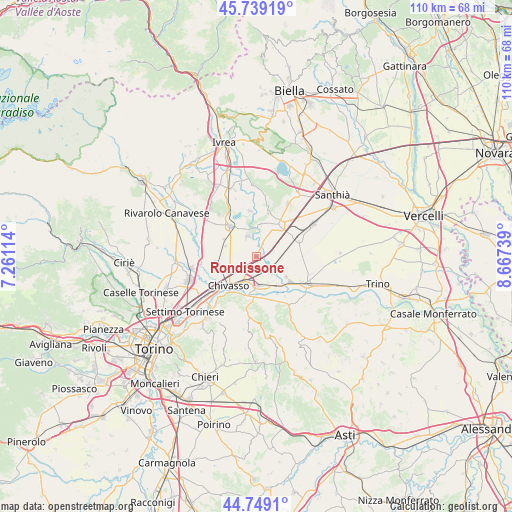
Rondissone GPS coordinates[2]
45° 14' 46.68" North, 7° 57' 51.336" East
| Map corner | latitude | longitude |
|---|---|---|
| Upper-left | 45.73919°, | 7.26114° |
| Center: | 45.2463°, | 7.96426° |
| Lower-right: | 44.7491°, | 8.66739° |
| Map W x H: | 110.1×110.1 km | = 68.4×68.4mi |
| max Lat: | 47.04031° ⇑33.9% North |
| Rondissone: | 45.2463° |
| min Lat: | ⇓66.1% South 35.50142° |
| min Long | Rondissone | max Long |
| 6.69888° | 7.96426° | 18.48682° |
| W 6%⇐ | ⇒94% E |
Elevation
Elevation of Rondissone is 214 m = 702 ft, and this is 92.7 m = 304 ft below average elevation for this country.
| Max E: |
2085 m = 6841 ft | 53.4% |
| Avg. | 306.7 m = 1006 ft | |
| Rondissone | 214 m = 702 ft | |
Min E: |
-4 m = -13 ft | 46.6% |
See also: Italy elevation on elevation.city.
Geographical zone
Rondissone is located in North temperate zone (between Tropic of Cancer and the Arctic Circle). Distance of this North polar circle is 2370.3 km =1472.8 mi to North.| Distance of | km | miles | from Rondissone |
|---|---|---|---|
| North Pole | 4976.1 | 3092 | to North |
| Arctic Circle | 2370.3 | 1472.8 | to North |
| Tropic Cancer | 2425 | 1506.8 | to South |
| Equator | 5030.9 | 3126.1 | to South |


Nearby cities:
15 places around Rondissone: (largest is in red/bold)
• Are
7 km =4.3 mi,  307°
307°
• Borgo Revel
7.5 km =4.7 mi,  142°
142°
• Boschetto
4.8 km =3 mi,  254°
254°
• Casabianca
3.2 km =2 mi,  207°
207°
• Chivasso
8.5 km =5.3 mi,  223°
223°
• Cigliano
8.3 km =5.2 mi,  33°
33°
• Mazze
6.5 km =4 mi,  337°
337°
• Rodallo
8 km =5 mi,  298°
298°
• Saluggia
4.1 km =2.5 mi,  104°
104°
• Sant'Antonino
6.6 km =4.1 mi,  84°
84°
• Tonengo-Casale
4.8 km =3 mi, 336°
• Torrazza Piemonte
3.6 km =2.2 mi,  164°
164°
• Vallo
7 km =4.3 mi,  289°
289°
• Verolengo
6.2 km =3.9 mi,  174°
174°
• Villareggia
7 km =4.3 mi,  8°
8°
Sources, notices
• [Note1] Compared only with cities in Italy existing in our database
• [Src1] Map data: © OpenStreetMap contributors (CC-BY-SA)
• [Src2] Other city data from geonames.org with taken over terms of usage.
• [Src3] Geographical zone / Annual Mean Temperature by Robert A. Rohde @ Wikipedia
