Vetto geodata
Vetto (Emilia-Romagna) is a seat of a third-order administrative division; located in Italy in Europe/Rome (GMT+2) time zone. With population of 683 people, there are 8407 cities with bigger population in this country. Compared to other cities in Italy, 50.8% of cities are located further ↓South; 64.6% of cities are located further →East and 74.2% of cities have lower elevation than Vetto. Note1
Administrative division(s):
- Level 1: Emilia-Romagna
- Level 2: Provincia di Reggio Emilia
- Level 3: Vetto


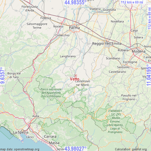
Vetto GPS coordinates[2]
44° 29' 2.652" North, 10° 20' 19.752" East
| Map corner | latitude | longitude |
|---|---|---|
| Upper-left | 44.98355°, | 9.6357° |
| Center: | 44.48407°, | 10.33882° |
| Lower-right: | 43.98027°, | 11.04195° |
| Map W x H: | 111.6×111.6 km | = 69.3×69.3mi |
| max Lat: | 47.04031° ⇑49.2% North |
| Vetto: | 44.48407° |
| min Lat: | ⇓50.8% South 35.50142° |
| min Long | Vetto | max Long |
| 6.69888° | 10.33882° | 18.48682° |
| W 35.4%⇐ | ⇒64.6% E |
Elevation
Elevation of Vetto is 442 m = 1450 ft, and this is 135.3 m = 444 ft above average elevation for this country.
| Max E: |
2085 m = 6841 ft | 25.8% |
| Vetto | 442 m 1450 ft | |
| Avg. | 306.7 m = 1006 ft | |
Min E: |
-4 m = -13 ft | 74.2% |
See also: Italy elevation on elevation.city.
Geographical zone
Vetto is located in North temperate zone (between Tropic of Cancer and the Arctic Circle). Distance of this Northern Tropic circle is 2340.2 km =1454.1 mi to South.| Distance of | km | miles | from Vetto |
|---|---|---|---|
| North Pole | 5060.9 | 3144.7 | to North |
| Arctic Circle | 2455 | 1525.5 | to North |
| Tropic Cancer | 2340.2 | 1454.1 | to South |
| Equator | 4946.2 | 3073.4 | to South |


Nearby cities:
15 places around Vetto: (largest is in red/bold)
• Busana
12.9 km =8 mi,  185°
185°
• Carpineti
14.5 km =9 mi,  102°
102°
• Casina
13.1 km =8.1 mi,  77°
77°
• Castelnovo ne'Monti
7.4 km =4.6 mi,  136°
136°
• Cervarezza
10.6 km =6.6 mi,  183°
183°
• Ciano d'Enza
14.1 km =8.8 mi,  23°
23°
• Collagna
16.1 km =10 mi,  198°
198°
• Felina
10.2 km =6.3 mi,  108°
108°
• Langhirano
16.1 km =10 mi,  339°
339°
• Mulazzano Ponte
14.3 km =8.9 mi, 337°
• Neviano degli Arduini
11.2 km =7 mi,  350°
350°
• Palanzano
12.7 km =7.9 mi,  245°
245°
• Ramiseto
9.3 km =5.8 mi,  211°
211°
• Tizzano Val Parma
11.8 km =7.3 mi,  289°
289°
• Villa Minozzo
16.6 km =10.3 mi, 142°
Sources, notices
• [Note1] Compared only with cities in Italy existing in our database
• [Src1] Map data: © OpenStreetMap contributors (CC-BY-SA)
• [Src2] Other city data from geonames.org with taken over terms of usage.
• [Src3] Geographical zone / Annual Mean Temperature by Robert A. Rohde @ Wikipedia
