Collagna geodata
Collagna (Emilia-Romagna) is a seat of a third-order administrative division; located in Italy in Europe/Rome (GMT+2) time zone. With population of 399 people, there are 10286 cities with bigger population in this country. Compared to other cities in Italy, 51.3% of cities are located further ↑North; 65.3% of cities are located further →East and 94% of cities have lower elevation than Collagna. Note1
Administrative division(s):
- Level 1: Emilia-Romagna
- Level 2: Provincia di Reggio Emilia
- Level 3: Ventasso


Collagna GPS coordinates[2]
44° 20' 48.984" North, 10° 16' 24.6" East
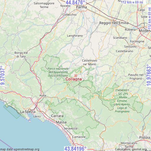
| Map corner | latitude | longitude |
|---|---|---|
| Upper-left | 44.8476°, | 9.57037° |
| Center: | 44.34694°, | 10.2735° |
| Lower-right: | 43.84196°, | 10.97663° |
| Map W x H: | 111.8×111.8 km | = 69.5×69.5mi |
| max Lat: | 47.04031° ⇑51.3% North |
| Collagna: | 44.34694° |
| min Lat: | ⇓48.7% South 35.50142° |
| min Long | Collagna | max Long |
| 6.69888° | 10.2735° | 18.48682° |
| W 34.7%⇐ | ⇒65.3% E |
Elevation
Elevation of Collagna is 838 m = 2749 ft, and this is 531.3 m = 1743 ft above average elevation for this country.
| Max E: |
2085 m = 6841 ft | 6% |
| Collagna | 838 m 2749 ft | |
| Avg. | 306.7 m = 1006 ft | |
Min E: |
-4 m = -13 ft | 94% |
See also: Italy elevation on elevation.city.
Geographical zone
Collagna is located in North temperate zone (between Tropic of Cancer and the Arctic Circle). Distance of this Northern Tropic circle is 2325 km =1444.7 mi to South.| Distance of | km | miles | from Collagna |
|---|---|---|---|
| North Pole | 5076.1 | 3154.1 | to North |
| Arctic Circle | 2470.3 | 1535 | to North |
| Tropic Cancer | 2325 | 1444.7 | to South |
| Equator | 4930.9 | 3063.9 | to South |


Nearby cities:
15 places around Collagna: (largest is in red/bold)
• Busana
4.7 km =2.9 mi,  58°
58°
• Casola in Lunigiana
18 km =11.2 mi,  205°
205°
• Castelnovo ne'Monti
14.3 km =8.9 mi,  46°
46°
• Cervarezza
6.5 km =4 mi,  44°
44°
• Comano
12.8 km =8 mi,  242°
242°
• Fivizzano
16.9 km =10.5 mi,  223°
223°
• Giuncugnano
15.3 km =9.5 mi,  187°
187°
• Ligonchio
6.4 km =4 mi,  121°
121°
• Monchio delle Corti
13.9 km =8.6 mi,  301°
301°
• Palanzano
11.8 km =7.3 mi,  327°
327°
• Piazza al Serchio-San Michele
18.2 km =11.3 mi,  174°
174°
• Ramiseto
7.3 km =4.5 mi,  2°
2°
• Sillano
14 km =8.7 mi, 170°
• Vetto
16.1 km =10 mi,  18°
18°
• Villa Minozzo
15.4 km =9.6 mi,  82°
82°
Sources, notices
• [Note1] Compared only with cities in Italy existing in our database
• [Src1] Map data: © OpenStreetMap contributors (CC-BY-SA)
• [Src2] Other city data from geonames.org with taken over terms of usage.
• [Src3] Geographical zone / Annual Mean Temperature by Robert A. Rohde @ Wikipedia
