Palanzano geodata
Palanzano (Emilia-Romagna) is a seat of a third-order administrative division; located in Italy in Europe/Rome (GMT+2) time zone. With population of 289 people, there are 10716 cities with bigger population in this country. Compared to other cities in Italy, 50.1% of cities are located further ↓South; 66% of cities are located further →East and 87.3% of cities have lower elevation than Palanzano. Note1


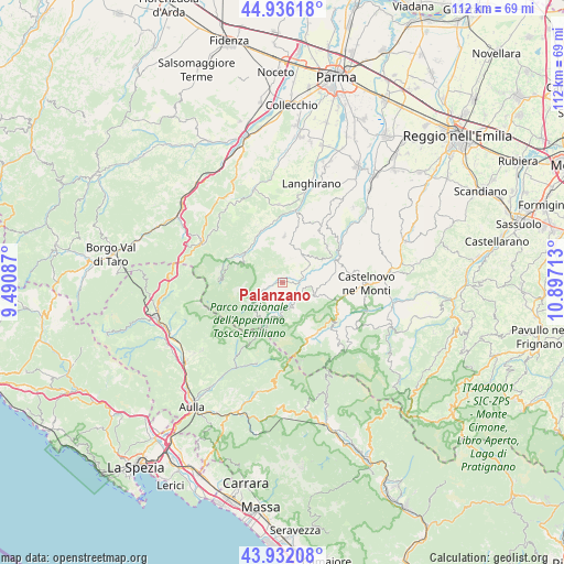
Palanzano GPS coordinates[2]
44° 26' 10.644" North, 10° 11' 38.4" East
| Map corner | latitude | longitude |
|---|---|---|
| Upper-left | 44.93618°, | 9.49087° |
| Center: | 44.43629°, | 10.194° |
| Lower-right: | 43.93208°, | 10.89713° |
| Map W x H: | 111.6×111.6 km | = 69.3×69.3mi |
| max Lat: | 47.04031° ⇑49.9% North |
| Palanzano: | 44.43629° |
| min Lat: | ⇓50.1% South 35.50142° |
| min Long | Palanzano | max Long |
| 6.69888° | 10.194° | 18.48682° |
| W 34%⇐ | ⇒66% E |
Elevation
Elevation of Palanzano is 659 m = 2162 ft, and this is 352.3 m = 1156 ft above average elevation for this country.
| Max E: |
2085 m = 6841 ft | 12.7% |
| Palanzano | 659 m 2162 ft | |
| Avg. | 306.7 m = 1006 ft | |
Min E: |
-4 m = -13 ft | 87.3% |
See also: Italy elevation on elevation.city.
Geographical zone
Palanzano is located in North temperate zone (between Tropic of Cancer and the Arctic Circle). Distance of this Northern Tropic circle is 2334.9 km =1450.8 mi to South.| Distance of | km | miles | from Palanzano |
|---|---|---|---|
| North Pole | 5066.2 | 3148 | to North |
| Arctic Circle | 2460.3 | 1528.8 | to North |
| Tropic Cancer | 2334.9 | 1450.8 | to South |
| Equator | 4940.9 | 3070.1 | to South |


Nearby cities:
15 places around Palanzano: (largest is in red/bold)
• Berceto
18 km =11.2 mi,  296°
296°
• Busana
12.7 km =7.9 mi,  126°
126°
• Calestano
19.3 km =12 mi,  343°
343°
• Castelnovo ne'Monti
16.6 km =10.3 mi,  90°
90°
• Cervarezza
12.1 km =7.5 mi,  115°
115°
• Collagna
11.8 km =7.3 mi,  147°
147°
• Comano
16.7 km =10.4 mi,  197°
197°
• Corniglio
9.3 km =5.8 mi, 297°
• Ligonchio
17.8 km =11.1 mi,  138°
138°
• Monchio delle Corti
6.2 km =3.9 mi,  243°
243°
• Mulazzano Ponte
19.4 km =12.1 mi,  17°
17°
• Neviano degli Arduini
19 km =11.8 mi,  30°
30°
• Ramiseto
7.1 km =4.4 mi,  111°
111°
• Tizzano Val Parma
9.2 km =5.7 mi,  2°
2°
• Vetto
12.7 km =7.9 mi,  65°
65°
Sources, notices
• [Note1] Compared only with cities in Italy existing in our database
• [Src1] Map data: © OpenStreetMap contributors (CC-BY-SA)
• [Src2] Other city data from geonames.org with taken over terms of usage.
• [Src3] Geographical zone / Annual Mean Temperature by Robert A. Rohde @ Wikipedia
