Vetrego geodata
Vetrego (Veneto) is a populated place; located in Italy in Europe/Rome (GMT+2) time zone. With population of 784 people, there are 7730 cities with bigger population in this country. Compared to other cities in Italy, 72.1% of cities are located further ↓South; 57.3% of cities are located further ←West and 99.4% of cities have higher elevation than Vetrego. Note1


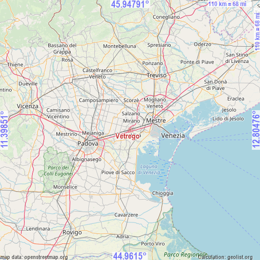
Vetrego GPS coordinates[2]
45° 27' 24.696" North, 12° 6' 5.868" East
| Map corner | latitude | longitude |
|---|---|---|
| Upper-left | 45.94791°, | 11.39851° |
| Center: | 45.45686°, | 12.10163° |
| Lower-right: | 44.9615°, | 12.80476° |
| Map W x H: | 109.7×109.7 km | = 68.2×68.2mi |
| max Lat: | 47.04031° ⇑27.9% North |
| Vetrego: | 45.45686° |
| min Lat: | ⇓72.1% South 35.50142° |
| min Long | Vetrego | max Long |
| 6.69888° | 12.10163° | 18.48682° |
| W 57.3%⇐ | ⇒42.7% E |
Elevation
Elevation of Vetrego is 1 m = 3 ft, and this is 305.7 m = 1003 ft below average elevation for this country.
| Max E: |
2085 m = 6841 ft | 99.4% |
| Avg. | 306.7 m = 1006 ft | |
| Vetrego | 1 m = 3 ft | |
Min E: |
-4 m = -13 ft | 0.6% |
See also: Italy elevation on elevation.city.
Geographical zone
Vetrego is located in North temperate zone (between Tropic of Cancer and the Arctic Circle). Distance of this North polar circle is 2346.8 km =1458.2 mi to North.| Distance of | km | miles | from Vetrego |
|---|---|---|---|
| North Pole | 4952.7 | 3077.5 | to North |
| Arctic Circle | 2346.8 | 1458.2 | to North |
| Tropic Cancer | 2448.4 | 1521.4 | to South |
| Equator | 5054.3 | 3140.6 | to South |


Nearby cities:
15 places around Vetrego: (largest is in red/bold)
• Arino
4.2 km =2.6 mi,  241°
241°
• Ballò
2.4 km =1.5 mi,  267°
267°
• Ca' Sabbioni
6.4 km =4 mi,  90°
90°
• Caltana
6.3 km =3.9 mi,  297°
297°
• Cavin-Botti
5.6 km =3.5 mi,  327°
327°
• Cazzago-Ex Polo
2.7 km =1.7 mi,  231°
231°
• Dolo
3.8 km =2.4 mi,  201°
201°
• Fornase
5.2 km =3.2 mi,  66°
66°
• Fossa
4.9 km =3 mi,  33°
33°
• Marano
1.4 km =0.9 mi,  58°
58°
• Mira Taglio
3.3 km =2.1 mi,  138°
138°
• Mirano
4.2 km =2.6 mi,  6°
6°
• Sambruson
5.2 km =3.2 mi,  178°
178°
• Scaltenigo
2.3 km =1.4 mi,  314°
314°
• Spinea-Orgnano
5.6 km =3.5 mi,  47°
47°
Sources, notices
• [Note1] Compared only with cities in Italy existing in our database
• [Src1] Map data: © OpenStreetMap contributors (CC-BY-SA)
• [Src2] Other city data from geonames.org with taken over terms of usage.
• [Src3] Geographical zone / Annual Mean Temperature by Robert A. Rohde @ Wikipedia
