Cavin-Botti geodata
Cavin-Botti (Veneto) is a populated place; located in Italy in Europe/Rome (GMT+2) time zone. With population of 631 people, there are 8769 cities with bigger population in this country. Compared to other cities in Italy, 73.6% of cities are located further ↓South; 56.8% of cities are located further ←West and 94.1% of cities have higher elevation than Cavin-Botti. Note1


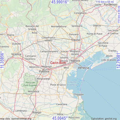
Cavin-Botti GPS coordinates[2]
45° 29' 58.164" North, 12° 3' 45.648" East
| Map corner | latitude | longitude |
|---|---|---|
| Upper-left | 45.99016°, | 11.35956° |
| Center: | 45.49949°, | 12.06268° |
| Lower-right: | 45.0045°, | 12.76581° |
| Map W x H: | 109.6×109.6 km | = 68.1×68.1mi |
| max Lat: | 47.04031° ⇑26.4% North |
| Cavin-Botti: | 45.49949° |
| min Lat: | ⇓73.6% South 35.50142° |
| min Long | Cavin-Botti | max Long |
| 6.69888° | 12.06268° | 18.48682° |
| W 56.8%⇐ | ⇒43.2% E |
Elevation
Elevation of Cavin-Botti is 10 m = 33 ft, and this is 296.7 m = 973 ft below average elevation for this country.
| Max E: |
2085 m = 6841 ft | 94.1% |
| Avg. | 306.7 m = 1006 ft | |
| Cavin-Botti | 10 m = 33 ft | |
Min E: |
-4 m = -13 ft | 5.9% |
See also: Italy elevation on elevation.city.
Geographical zone
Cavin-Botti is located in North temperate zone (between Tropic of Cancer and the Arctic Circle). Distance of this North polar circle is 2342.1 km =1455.3 mi to North.| Distance of | km | miles | from Cavin-Botti |
|---|---|---|---|
| North Pole | 4948 | 3074.5 | to North |
| Arctic Circle | 2342.1 | 1455.3 | to North |
| Tropic Cancer | 2453.2 | 1524.3 | to South |
| Equator | 5059.1 | 3143.6 | to South |


Nearby cities:
15 places around Cavin-Botti: (largest is in red/bold)
• Ballò
4.9 km =3 mi,  172°
172°
• Caltana
3.2 km =2 mi,  233°
233°
• Caselle
4.6 km =2.9 mi,  251°
251°
• Fossa
5.7 km =3.5 mi,  96°
96°
• Marano
5.8 km =3.6 mi,  133°
133°
• Mirano
3.6 km =2.2 mi, 98°
• Noale
5.2 km =3.2 mi,  1°
1°
• Salzano
3.9 km =2.4 mi,  50°
50°
• Sant'Angelo
4.1 km =2.5 mi,  303°
303°
• Santa Maria di Sala
2.3 km =1.4 mi,  291°
291°
• Scaltenigo
3.5 km =2.2 mi,  155°
155°
• Stigliano
3.1 km =1.9 mi,  331°
331°
• Veternigo
2.1 km =1.3 mi,  349°
349°
• Vetrego
5.6 km =3.5 mi,  147°
147°
• Zeminiana
4.8 km =3 mi,  321°
321°
Sources, notices
• [Note1] Compared only with cities in Italy existing in our database
• [Src1] Map data: © OpenStreetMap contributors (CC-BY-SA)
• [Src2] Other city data from geonames.org with taken over terms of usage.
• [Src3] Geographical zone / Annual Mean Temperature by Robert A. Rohde @ Wikipedia
