Cazzago-Ex Polo geodata
Cazzago-Ex Polo (Veneto) is a populated place; located in Italy in Europe/Rome (GMT+2) time zone. With population of 4,226 people, there are 2270 cities with bigger population in this country. Compared to other cities in Italy, 71.6% of cities are located further ↓South; 56.9% of cities are located further ←West and 98.4% of cities have higher elevation than Cazzago-Ex Polo. Note1


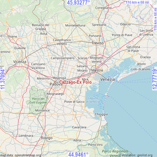
Cazzago-Ex Polo GPS coordinates[2]
45° 26' 29.724" North, 12° 4' 26.616" East
| Map corner | latitude | longitude |
|---|---|---|
| Upper-left | 45.93277°, | 11.37094° |
| Center: | 45.44159°, | 12.07406° |
| Lower-right: | 44.9461°, | 12.77719° |
| Map W x H: | 109.7×109.7 km | = 68.2×68.2mi |
| max Lat: | 47.04031° ⇑28.4% North |
| Cazzago-Ex Polo: | 45.44159° |
| min Lat: | ⇓71.6% South 35.50142° |
| min Long | Cazzago-Ex Polo | max Long |
| 6.69888° | 12.07406° | 18.48682° |
| W 56.9%⇐ | ⇒43.1% E |
Elevation
Elevation of Cazzago-Ex Polo is 3 m = 10 ft, and this is 303.7 m = 996 ft below average elevation for this country.
| Max E: |
2085 m = 6841 ft | 98.4% |
| Avg. | 306.7 m = 1006 ft | |
| Cazzago-Ex Polo | 3 m = 10 ft | |
Min E: |
-4 m = -13 ft | 1.6% |
See also: Italy elevation on elevation.city.
Geographical zone
Cazzago-Ex Polo is located in North temperate zone (between Tropic of Cancer and the Arctic Circle). Distance of this North polar circle is 2348.5 km =1459.3 mi to North.| Distance of | km | miles | from Cazzago-Ex Polo |
|---|---|---|---|
| North Pole | 4954.4 | 3078.5 | to North |
| Arctic Circle | 2348.5 | 1459.3 | to North |
| Tropic Cancer | 2446.7 | 1520.3 | to South |
| Equator | 5052.6 | 3139.5 | to South |


Nearby cities:
15 places around Cazzago-Ex Polo: (largest is in red/bold)
• Arino
1.6 km =1 mi,  257°
257°
• Ballò
1.6 km =1 mi,  352°
352°
• Brigo-Paluello
3.9 km =2.4 mi,  207°
207°
• Caltana
5.7 km =3.5 mi,  323°
323°
• Dolo
2 km =1.2 mi,  156°
156°
• Fiesso
4 km =2.5 mi,  232°
232°
• Fiesso d'Artico
4.1 km =2.5 mi,  237°
237°
• Marano
4.1 km =2.5 mi,  54°
54°
• Mira Taglio
4.4 km =2.7 mi,  100°
100°
• Mirano
6.5 km =4 mi,  24°
24°
• Pianiga
5.5 km =3.4 mi,  288°
288°
• Sambruson
4.1 km =2.5 mi,  146°
146°
• Scaltenigo
3.3 km =2.1 mi,  9°
9°
• Stra
5.8 km =3.6 mi, 234°
• Vetrego
2.7 km =1.7 mi, 51°
Sources, notices
• [Note1] Compared only with cities in Italy existing in our database
• [Src1] Map data: © OpenStreetMap contributors (CC-BY-SA)
• [Src2] Other city data from geonames.org with taken over terms of usage.
• [Src3] Geographical zone / Annual Mean Temperature by Robert A. Rohde @ Wikipedia
