Vertova geodata
Vertova (Lombardy) is a seat of a third-order administrative division; located in Italy in Europe/Rome (GMT+2) time zone. With population of 4,714 people, there are 2065 cities with bigger population in this country. Compared to other cities in Italy, 86.2% of cities are located further ↓South; 69.3% of cities are located further →East and 71.7% of cities have lower elevation than Vertova. Note1


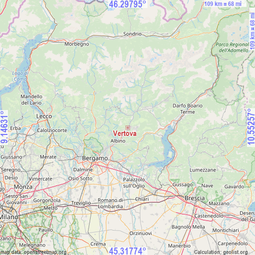
Vertova GPS coordinates[2]
45° 48' 36" North, 9° 50' 57.984" East
| Map corner | latitude | longitude |
|---|---|---|
| Upper-left | 46.29795°, | 9.14631° |
| Center: | 45.81°, | 9.84944° |
| Lower-right: | 45.31774°, | 10.55257° |
| Map W x H: | 109×109 km | = 67.7×67.7mi |
| max Lat: | 47.04031° ⇑13.8% North |
| Vertova: | 45.81° |
| min Lat: | ⇓86.2% South 35.50142° |
| min Long | Vertova | max Long |
| 6.69888° | 9.84944° | 18.48682° |
| W 30.7%⇐ | ⇒69.3% E |
Elevation
Elevation of Vertova is 412 m = 1352 ft, and this is 105.3 m = 345 ft above average elevation for this country.
| Max E: |
2085 m = 6841 ft | 28.3% |
| Vertova | 412 m 1352 ft | |
| Avg. | 306.7 m = 1006 ft | |
Min E: |
-4 m = -13 ft | 71.7% |
See also: Italy elevation on elevation.city.
Geographical zone
Vertova is located in North temperate zone (between Tropic of Cancer and the Arctic Circle). Distance of this North polar circle is 2307.6 km =1433.9 mi to North.| Distance of | km | miles | from Vertova |
|---|---|---|---|
| North Pole | 4913.5 | 3053.1 | to North |
| Arctic Circle | 2307.6 | 1433.9 | to North |
| Tropic Cancer | 2487.7 | 1545.8 | to South |
| Equator | 5093.6 | 3165 | to South |


Nearby cities:
15 places around Vertova: (largest is in red/bold)
• Aviatico
6.2 km =3.9 mi,  257°
257°
• Casnigo
1.5 km =0.9 mi,  77°
77°
• Cazzano Sant'Andrea
2.8 km =1.7 mi,  87°
87°
• Cene
3.7 km =2.3 mi,  208°
208°
• Colzate
1 km =0.6 mi,  33°
33°
• Fiorano al Serio
1.2 km =0.7 mi, 205°
• Gandino
3.7 km =2.3 mi, 88°
• Gazzaniga
2.4 km =1.5 mi,  219°
219°
• Gorno
5.9 km =3.7 mi,  354°
354°
• Leffe
3 km =1.9 mi,  116°
116°
• Masserini
1.6 km =1 mi,  239°
239°
• Orezzo
2.2 km =1.4 mi, 256°
• Peia
4 km =2.5 mi,  106°
106°
• Vall'Alta
5.7 km =3.5 mi,  198°
198°
• Villassio
5.9 km =3.7 mi,  356°
356°
Sources, notices
• [Note1] Compared only with cities in Italy existing in our database
• [Src1] Map data: © OpenStreetMap contributors (CC-BY-SA)
• [Src2] Other city data from geonames.org with taken over terms of usage.
• [Src3] Geographical zone / Annual Mean Temperature by Robert A. Rohde @ Wikipedia
