Casnigo geodata
Casnigo (Lombardy) is a seat of a third-order administrative division; located in Italy in Europe/Rome (GMT+2) time zone. With population of 3,047 people, there are 2999 cities with bigger population in this country. Compared to other cities in Italy, 86.3% of cities are located further ↓South; 69.2% of cities are located further →East and 78.9% of cities have lower elevation than Casnigo. Note1


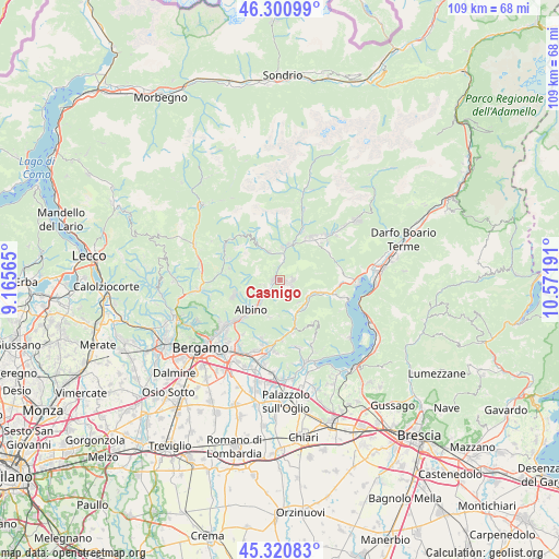
Casnigo GPS coordinates[2]
45° 48' 47.052" North, 9° 52' 7.608" East
| Map corner | latitude | longitude |
|---|---|---|
| Upper-left | 46.30099°, | 9.16565° |
| Center: | 45.81307°, | 9.86878° |
| Lower-right: | 45.32083°, | 10.57191° |
| Map W x H: | 109×109 km | = 67.7×67.7mi |
| max Lat: | 47.04031° ⇑13.7% North |
| Casnigo: | 45.81307° |
| min Lat: | ⇓86.3% South 35.50142° |
| min Long | Casnigo | max Long |
| 6.69888° | 9.86878° | 18.48682° |
| W 30.8%⇐ | ⇒69.2% E |
Elevation
Elevation of Casnigo is 506 m = 1660 ft, and this is 199.3 m = 654 ft above average elevation for this country.
| Max E: |
2085 m = 6841 ft | 21.1% |
| Casnigo | 506 m 1660 ft | |
| Avg. | 306.7 m = 1006 ft | |
Min E: |
-4 m = -13 ft | 78.9% |
See also: Italy elevation on elevation.city.
Geographical zone
Casnigo is located in North temperate zone (between Tropic of Cancer and the Arctic Circle). Distance of this North polar circle is 2307.2 km =1433.6 mi to North.| Distance of | km | miles | from Casnigo |
|---|---|---|---|
| North Pole | 4913.1 | 3052.9 | to North |
| Arctic Circle | 2307.2 | 1433.6 | to North |
| Tropic Cancer | 2488 | 1546 | to South |
| Equator | 5093.9 | 3165.2 | to South |


Nearby cities:
15 places around Casnigo: (largest is in red/bold)
• Bianzano
5.9 km =3.7 mi,  139°
139°
• Cazzano Sant'Andrea
1.3 km =0.8 mi,  99°
99°
• Cene
4.9 km =3 mi,  222°
222°
• Colzate
1.1 km =0.7 mi,  295°
295°
• Fiorano al Serio
2.5 km =1.6 mi,  234°
234°
• Gandino
2.3 km =1.4 mi, 96°
• Gazzaniga
3.7 km =2.3 mi, 234°
• Gorno
5.9 km =3.7 mi,  338°
338°
• Leffe
2.1 km =1.3 mi, 144°
• Masserini
3.1 km =1.9 mi,  248°
248°
• Orezzo
3.7 km =2.3 mi,  256°
256°
• Peia
2.8 km =1.7 mi,  122°
122°
• Ranzanico
5.8 km =3.6 mi, 118°
• Vertova
1.5 km =0.9 mi, 257°
• Villassio
5.9 km =3.7 mi, 341°
Sources, notices
• [Note1] Compared only with cities in Italy existing in our database
• [Src1] Map data: © OpenStreetMap contributors (CC-BY-SA)
• [Src2] Other city data from geonames.org with taken over terms of usage.
• [Src3] Geographical zone / Annual Mean Temperature by Robert A. Rohde @ Wikipedia
