Verona geodata
Verona (Veneto) is a seat of a second-order administrative division; located in Italy in Europe/Rome (GMT+2) time zone. With population of 219,103 people, there are 11 cities with bigger population in this country. Compared to other cities in Italy, 71.2% of cities are located further ↓South; 57.5% of cities are located further →East and 77.5% of cities have higher elevation than Verona. Note1


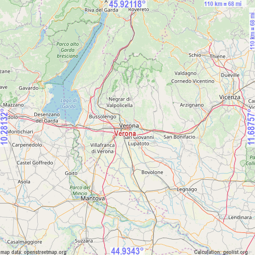
Verona GPS coordinates[2]
45° 25' 47.64" North, 10° 59' 3.984" East
| Map corner | latitude | longitude |
|---|---|---|
| Upper-left | 45.92118°, | 10.28132° |
| Center: | 45.4299°, | 10.98444° |
| Lower-right: | 44.9343°, | 11.68757° |
| Map W x H: | 109.7×109.7 km | = 68.2×68.2mi |
| max Lat: | 47.04031° ⇑28.8% North |
| Verona: | 45.4299° |
| min Lat: | ⇓71.2% South 35.50142° |
| min Long | Verona | max Long |
| 6.69888° | 10.98444° | 18.48682° |
| W 42.5%⇐ | ⇒57.5% E |
Elevation
Elevation of Verona is 62 m = 203 ft, and this is 244.7 m = 803 ft below average elevation for this country.
| Max E: |
2085 m = 6841 ft | 77.5% |
| Avg. | 306.7 m = 1006 ft | |
| Verona | 62 m = 203 ft | |
Min E: |
-4 m = -13 ft | 22.5% |
See also: Verona elevation on elevation.city.
Geographical zone
Verona is located in North temperate zone (between Tropic of Cancer and the Arctic Circle). Distance of this North polar circle is 2349.8 km =1460.1 mi to North.| Distance of | km | miles | from Verona |
|---|---|---|---|
| North Pole | 4955.7 | 3079.3 | to North |
| Arctic Circle | 2349.8 | 1460.1 | to North |
| Tropic Cancer | 2445.4 | 1519.5 | to South |
| Equator | 5051.3 | 3138.7 | to South |


Nearby cities:
15 places around Verona: (largest is in red/bold)
• Alpo
7.8 km =4.8 mi,  220°
220°
• Bassone
7.4 km =4.6 mi,  288°
288°
• Beccacivetta-Azzano
6.4 km =4 mi,  196°
196°
• Caselle
7.2 km =4.5 mi,  255°
255°
• Dossobuono
7.1 km =4.4 mi,  234°
234°
• Lugagnano
7.8 km =4.8 mi,  272°
272°
• Madonna di Dossobuono
4.8 km =3 mi,  242°
242°
• Marchesino-Bovo
7.1 km =4.4 mi,  170°
170°
• Montericco
7.3 km =4.5 mi,  342°
342°
• Montorio
7.1 km =4.4 mi,  63°
63°
• Parona
6.3 km =3.9 mi,  329°
329°
• Poiano
5.2 km =3.2 mi,  30°
30°
• San Felice
5.1 km =3.2 mi,  49°
49°
• San Giovanni Lupatoto
7.1 km =4.4 mi,  138°
138°
• San Pancrazio
3 km =1.9 mi,  101°
101°
Sources, notices
• [Note1] Compared only with cities in Italy existing in our database
• [Src1] Map data: © OpenStreetMap contributors (CC-BY-SA)
• [Src2] Other city data from geonames.org with taken over terms of usage.
• [Src3] Geographical zone / Annual Mean Temperature by Robert A. Rohde @ Wikipedia
