Lugagnano geodata
Lugagnano (Veneto) is a populated place; located in Italy in Europe/Rome (GMT+2) time zone. With population of 8,383 people, there are 1149 cities with bigger population in this country. Compared to other cities in Italy, 71.4% of cities are located further ↓South; 58.7% of cities are located further →East and 71.1% of cities have higher elevation than Lugagnano. Note1


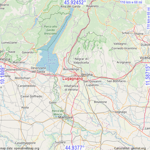
Lugagnano GPS coordinates[2]
45° 25' 59.772" North, 10° 53' 2.472" East
| Map corner | latitude | longitude |
|---|---|---|
| Upper-left | 45.92452°, | 10.1809° |
| Center: | 45.43327°, | 10.88402° |
| Lower-right: | 44.9377°, | 11.58715° |
| Map W x H: | 109.7×109.7 km | = 68.2×68.2mi |
| max Lat: | 47.04031° ⇑28.6% North |
| Lugagnano: | 45.43327° |
| min Lat: | ⇓71.4% South 35.50142° |
| min Long | Lugagnano | max Long |
| 6.69888° | 10.88402° | 18.48682° |
| W 41.3%⇐ | ⇒58.7% E |
Elevation
Elevation of Lugagnano is 92 m = 302 ft, and this is 214.7 m = 704 ft below average elevation for this country.
| Max E: |
2085 m = 6841 ft | 71.1% |
| Avg. | 306.7 m = 1006 ft | |
| Lugagnano | 92 m = 302 ft | |
Min E: |
-4 m = -13 ft | 28.9% |
See also: Italy elevation on elevation.city.
Geographical zone
Lugagnano is located in North temperate zone (between Tropic of Cancer and the Arctic Circle). Distance of this North polar circle is 2349.5 km =1459.9 mi to North.| Distance of | km | miles | from Lugagnano |
|---|---|---|---|
| North Pole | 4955.4 | 3079.1 | to North |
| Arctic Circle | 2349.5 | 1459.9 | to North |
| Tropic Cancer | 2445.8 | 1519.7 | to South |
| Equator | 5051.7 | 3139 | to South |


Nearby cities:
15 places around Lugagnano: (largest is in red/bold)
• Alpo
6.9 km =4.3 mi,  155°
155°
• Bassone
2.1 km =1.3 mi,  22°
22°
• Bussolengo
4.6 km =2.9 mi,  329°
329°
• Caluri
5.9 km =3.7 mi,  184°
184°
• Caselle
2.4 km =1.5 mi, 157°
• Corrubbio
6.1 km =3.8 mi,  14°
14°
• Dossobuono
4.9 km =3 mi, 155°
• Madonna di Dossobuono
4.5 km =2.8 mi,  125°
125°
• Parona
6.9 km =4.3 mi,  42°
42°
• Pescantina
5.9 km =3.7 mi,  347°
347°
• San Vito al Mantico
4.3 km =2.7 mi, 8°
• Settimo
5.5 km =3.4 mi, 20°
• Sommacampagna
4.4 km =2.7 mi,  225°
225°
• Sona
3.4 km =2.1 mi,  268°
268°
• Via Pastrengo
6.4 km =4 mi,  318°
318°
Sources, notices
• [Note1] Compared only with cities in Italy existing in our database
• [Src1] Map data: © OpenStreetMap contributors (CC-BY-SA)
• [Src2] Other city data from geonames.org with taken over terms of usage.
• [Src3] Geographical zone / Annual Mean Temperature by Robert A. Rohde @ Wikipedia
