Verolengo geodata
Verolengo (Piedmont) is a seat of a third-order administrative division; located in Italy in Europe/Rome (GMT+2) time zone. With population of 2,575 people, there are 3434 cities with bigger population in this country. Compared to other cities in Italy, 64.7% of cities are located further ↓South; 93.9% of cities are located further →East and 59% of cities have higher elevation than Verolengo. Note1


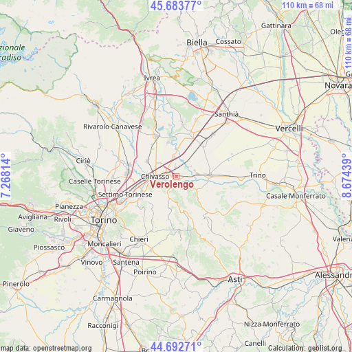
Verolengo GPS coordinates[2]
45° 11' 25.44" North, 7° 58' 16.536" East
| Map corner | latitude | longitude |
|---|---|---|
| Upper-left | 45.68377°, | 7.26814° |
| Center: | 45.1904°, | 7.97126° |
| Lower-right: | 44.69271°, | 8.67439° |
| Map W x H: | 110.2×110.2 km | = 68.5×68.5mi |
| max Lat: | 47.04031° ⇑35.3% North |
| Verolengo: | 45.1904° |
| min Lat: | ⇓64.7% South 35.50142° |
| min Long | Verolengo | max Long |
| 6.69888° | 7.97126° | 18.48682° |
| W 6.1%⇐ | ⇒93.9% E |
Elevation
Elevation of Verolengo is 171 m = 561 ft, and this is 135.7 m = 445 ft below average elevation for this country.
| Max E: |
2085 m = 6841 ft | 59% |
| Avg. | 306.7 m = 1006 ft | |
| Verolengo | 171 m = 561 ft | |
Min E: |
-4 m = -13 ft | 41% |
See also: Italy elevation on elevation.city.
Geographical zone
Verolengo is located in North temperate zone (between Tropic of Cancer and the Arctic Circle). Distance of this North polar circle is 2376.5 km =1476.7 mi to North.| Distance of | km | miles | from Verolengo |
|---|---|---|---|
| North Pole | 4982.4 | 3095.9 | to North |
| Arctic Circle | 2376.5 | 1476.7 | to North |
| Tropic Cancer | 2418.8 | 1503 | to South |
| Equator | 5024.7 | 3122.2 | to South |


Nearby cities:
15 places around Verolengo: (largest is in red/bold)
• Borgo Revel
4 km =2.5 mi,  86°
86°
• Boschetto
7.1 km =4.4 mi,  313°
313°
• Brusasco
8.1 km =5 mi,  119°
119°
• Casabianca
3.9 km =2.4 mi,  329°
329°
• Casalborgone
7.1 km =4.4 mi,  199°
199°
• Castagneto Po
7.5 km =4.7 mi,  241°
241°
• Cavagnolo
7.5 km =4.7 mi,  125°
125°
• Chivasso
6.4 km =4 mi,  270°
270°
• Lauriano
3.9 km =2.4 mi,  151°
151°
• Monteu da Po
5.6 km =3.5 mi,  142°
142°
• Pomaretto
7.3 km =4.5 mi, 125°
• Rondissone
6.2 km =3.9 mi,  354°
354°
• Saluggia
6.2 km =3.9 mi,  33°
33°
• San Sebastiano da Po
2.8 km =1.7 mi, 203°
• Torrazza Piemonte
2.8 km =1.7 mi,  8°
8°
Sources, notices
• [Note1] Compared only with cities in Italy existing in our database
• [Src1] Map data: © OpenStreetMap contributors (CC-BY-SA)
• [Src2] Other city data from geonames.org with taken over terms of usage.
• [Src3] Geographical zone / Annual Mean Temperature by Robert A. Rohde @ Wikipedia
