Saluggia geodata
Saluggia (Piedmont) is a seat of a third-order administrative division; located in Italy in Europe/Rome (GMT+2) time zone. With population of 2,989 people, there are 3052 cities with bigger population in this country. Compared to other cities in Italy, 65.8% of cities are located further ↓South; 93.4% of cities are located further →East and 56.2% of cities have higher elevation than Saluggia. Note1


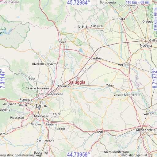
Saluggia GPS coordinates[2]
45° 14' 12.732" North, 8° 0' 52.56" East
| Map corner | latitude | longitude |
|---|---|---|
| Upper-left | 45.72984°, | 7.31147° |
| Center: | 45.23687°, | 8.0146° |
| Lower-right: | 44.73959°, | 8.71772° |
| Map W x H: | 110.1×110.1 km | = 68.4×68.4mi |
| max Lat: | 47.04031° ⇑34.2% North |
| Saluggia: | 45.23687° |
| min Lat: | ⇓65.8% South 35.50142° |
| min Long | Saluggia | max Long |
| 6.69888° | 8.0146° | 18.48682° |
| W 6.6%⇐ | ⇒93.4% E |
Elevation
Elevation of Saluggia is 194 m = 636 ft, and this is 112.7 m = 370 ft below average elevation for this country.
| Max E: |
2085 m = 6841 ft | 56.2% |
| Avg. | 306.7 m = 1006 ft | |
| Saluggia | 194 m = 636 ft | |
Min E: |
-4 m = -13 ft | 43.8% |
See also: Italy elevation on elevation.city.
Geographical zone
Saluggia is located in North temperate zone (between Tropic of Cancer and the Arctic Circle). Distance of this North polar circle is 2371.3 km =1473.5 mi to North.| Distance of | km | miles | from Saluggia |
|---|---|---|---|
| North Pole | 4977.2 | 3092.7 | to North |
| Arctic Circle | 2371.3 | 1473.5 | to North |
| Tropic Cancer | 2423.9 | 1506.1 | to South |
| Equator | 5029.9 | 3125.4 | to South |


Nearby cities:
15 places around Saluggia: (largest is in red/bold)
• Borgo Revel
4.9 km =3 mi,  173°
173°
• Boschetto
8.6 km =5.3 mi,  268°
268°
• Casabianca
5.7 km =3.5 mi,  251°
251°
• Cigliano
7.9 km =4.9 mi,  4°
4°
• Crescentino
7 km =4.3 mi,  126°
126°
• Lamporo
6.6 km =4.1 mi,  95°
95°
• Lauriano
8.7 km =5.4 mi,  190°
190°
• Livorno Ferraris
7.1 km =4.4 mi,  44°
44°
• Rondissone
4.1 km =2.5 mi,  284°
284°
• San Sebastiano da Po
8.9 km =5.5 mi,  210°
210°
• Sant'Antonino
3.1 km =1.9 mi,  58°
58°
• Tonengo-Casale
8 km =5 mi,  313°
313°
• Torrazza Piemonte
3.8 km =2.4 mi,  231°
231°
• Verolengo
6.2 km =3.9 mi, 213°
• Villareggia
8.5 km =5.3 mi,  339°
339°
Sources, notices
• [Note1] Compared only with cities in Italy existing in our database
• [Src1] Map data: © OpenStreetMap contributors (CC-BY-SA)
• [Src2] Other city data from geonames.org with taken over terms of usage.
• [Src3] Geographical zone / Annual Mean Temperature by Robert A. Rohde @ Wikipedia
