Ventosa geodata
Ventosa (Latium) is a populated place; located in Italy in Europe/Rome (GMT+2) time zone. With population of 540 people, there are 9547 cities with bigger population in this country. Compared to other cities in Italy, 76.5% of cities are located further ↑North; 76.7% of cities are located further ←West and 93.6% of cities have higher elevation than Ventosa. Note1
Administrative division(s):
- Level 1: Latium
- Level 2: Provincia di Latina
- Level 3: Santi Cosma e Damiano


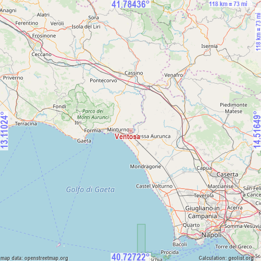
Ventosa GPS coordinates[2]
41° 15' 28.548" North, 13° 48' 48.096" East
| Map corner | latitude | longitude |
|---|---|---|
| Upper-left | 41.78436°, | 13.11024° |
| Center: | 41.25793°, | 13.81336° |
| Lower-right: | 40.72722°, | 14.51649° |
| Map W x H: | 117.5×117.5 km | = 73×73mi |
| max Lat: | 47.04031° ⇑76.5% North |
| Ventosa: | 41.25793° |
| min Lat: | ⇓23.5% South 35.50142° |
| min Long | Ventosa | max Long |
| 6.69888° | 13.81336° | 18.48682° |
| W 76.7%⇐ | ⇒23.3% E |
Elevation
Elevation of Ventosa is 11 m = 36 ft, and this is 295.7 m = 970 ft below average elevation for this country.
| Max E: |
2085 m = 6841 ft | 93.6% |
| Avg. | 306.7 m = 1006 ft | |
| Ventosa | 11 m = 36 ft | |
Min E: |
-4 m = -13 ft | 6.4% |
See also: Italy elevation on elevation.city.
Geographical zone
Ventosa is located in North temperate zone (between Tropic of Cancer and the Arctic Circle). Distance of this Northern Tropic circle is 1981.5 km =1231.2 mi to South.| Distance of | km | miles | from Ventosa |
|---|---|---|---|
| North Pole | 5419.6 | 3367.6 | to North |
| Arctic Circle | 2813.7 | 1748.4 | to North |
| Tropic Cancer | 1981.5 | 1231.2 | to South |
| Equator | 4587.5 | 2850.5 | to South |


Nearby cities:
15 places around Ventosa: (largest is in red/bold)
• Carano
10 km =6.2 mi,  126°
126°
• Castelforte
4.3 km =2.7 mi,  19°
19°
• Cellole
6.9 km =4.3 mi,  151°
151°
• Cerri Aprano
4.6 km =2.9 mi,  320°
320°
• Forme di Suio-San Cataldo
5.5 km =3.4 mi,  42°
42°
• Grunuovo-Campomaggiore San Luca
1.7 km =1.1 mi,  341°
341°
• Lauro
6.5 km =4 mi,  84°
84°
• Minturno
5.7 km =3.5 mi,  275°
275°
• Penitro
10.2 km =6.3 mi, 279°
• San Castrese
4.4 km =2.7 mi,  88°
88°
• Santa Maria Infante
7.1 km =4.4 mi,  300°
300°
• Santi Cosma e Damiano
4.8 km =3 mi,  2°
2°
• Sessa Aurunca
9.9 km =6.2 mi,  101°
101°
• Spigno Saturnia Inferiore
8.7 km =5.4 mi,  312°
312°
• Tufo
4.2 km =2.6 mi, 283°
Sources, notices
• [Note1] Compared only with cities in Italy existing in our database
• [Src1] Map data: © OpenStreetMap contributors (CC-BY-SA)
• [Src2] Other city data from geonames.org with taken over terms of usage.
• [Src3] Geographical zone / Annual Mean Temperature by Robert A. Rohde @ Wikipedia
