Lauro geodata
Lauro (Campania) is a populated place; located in Italy in Europe/Rome (GMT+2) time zone. With population of 1,435 people, there are 5278 cities with bigger population in this country. Compared to other cities in Italy, 76.4% of cities are located further ↑North; 77.4% of cities are located further ←West and 69.6% of cities have higher elevation than Lauro. Note1


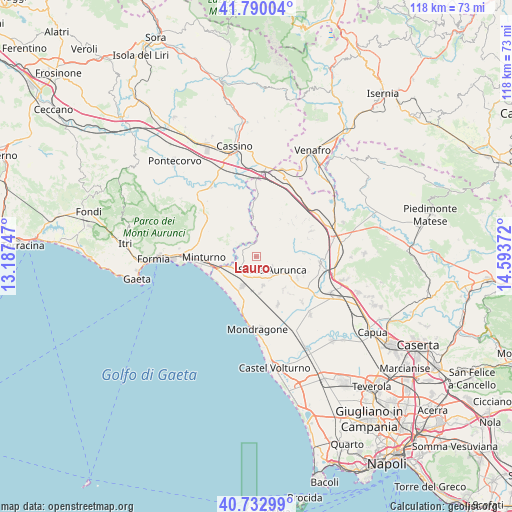
Lauro GPS coordinates[2]
41° 15' 49.14" North, 13° 53' 26.124" East
| Map corner | latitude | longitude |
|---|---|---|
| Upper-left | 41.79004°, | 13.18747° |
| Center: | 41.26365°, | 13.89059° |
| Lower-right: | 40.73299°, | 14.59372° |
| Map W x H: | 117.5×117.5 km | = 73×73mi |
| max Lat: | 47.04031° ⇑76.4% North |
| Lauro: | 41.26365° |
| min Lat: | ⇓23.6% South 35.50142° |
| min Long | Lauro | max Long |
| 6.69888° | 13.89059° | 18.48682° |
| W 77.4%⇐ | ⇒22.6% E |
Elevation
Elevation of Lauro is 100 m = 328 ft, and this is 206.7 m = 678 ft below average elevation for this country.
| Max E: |
2085 m = 6841 ft | 69.6% |
| Avg. | 306.7 m = 1006 ft | |
| Lauro | 100 m = 328 ft | |
Min E: |
-4 m = -13 ft | 30.4% |
See also: Italy elevation on elevation.city.
Geographical zone
Lauro is located in North temperate zone (between Tropic of Cancer and the Arctic Circle). Distance of this Northern Tropic circle is 1982.2 km =1231.7 mi to South.| Distance of | km | miles | from Lauro |
|---|---|---|---|
| North Pole | 5419 | 3367.2 | to North |
| Arctic Circle | 2813.1 | 1748 | to North |
| Tropic Cancer | 1982.2 | 1231.7 | to South |
| Equator | 4588.1 | 2850.9 | to South |


Nearby cities:
15 places around Lauro: (largest is in red/bold)
• Avezzano-Sorbello
6.3 km =3.9 mi,  145°
145°
• Carano
6.7 km =4.2 mi,  166°
166°
• Cascano
7.4 km =4.6 mi,  117°
117°
• Castelforte
6 km =3.7 mi,  303°
303°
• Cellole
7.4 km =4.6 mi,  204°
204°
• Forme di Suio-San Cataldo
4.4 km =2.7 mi,  321°
321°
• Grunuovo-Campomaggiore San Luca
7.1 km =4.4 mi,  277°
277°
• Piedimonte
8.3 km =5.2 mi,  175°
175°
• Roccamonfina
7.8 km =4.8 mi,  70°
70°
• San Carlo
5.7 km =3.5 mi,  23°
23°
• San Castrese
2.2 km =1.4 mi,  255°
255°
• Sant'Agata
5.6 km =3.5 mi,  136°
136°
• Santi Cosma e Damiano
7.5 km =4.7 mi, 303°
• Sessa Aurunca
4.2 km =2.6 mi,  128°
128°
• Ventosa
6.5 km =4 mi, 264°
Sources, notices
• [Note1] Compared only with cities in Italy existing in our database
• [Src1] Map data: © OpenStreetMap contributors (CC-BY-SA)
• [Src2] Other city data from geonames.org with taken over terms of usage.
• [Src3] Geographical zone / Annual Mean Temperature by Robert A. Rohde @ Wikipedia
