Castelforte geodata
Castelforte (Latium) is a seat of a third-order administrative division; located in Italy in Europe/Rome (GMT+2) time zone. With population of 2,676 people, there are 3337 cities with bigger population in this country. Compared to other cities in Italy, 76.2% of cities are located further ↑North; 76.9% of cities are located further ←West and 79.6% of cities have higher elevation than Castelforte. Note1


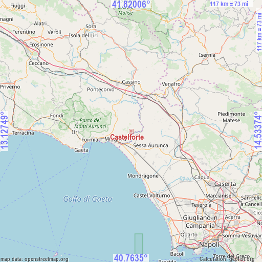
Castelforte GPS coordinates[2]
41° 17' 38.112" North, 13° 49' 50.196" East
| Map corner | latitude | longitude |
|---|---|---|
| Upper-left | 41.82006°, | 13.12749° |
| Center: | 41.29392°, | 13.83061° |
| Lower-right: | 40.7635°, | 14.53374° |
| Map W x H: | 117.5×117.5 km | = 73×73mi |
| max Lat: | 47.04031° ⇑76.2% North |
| Castelforte: | 41.29392° |
| min Lat: | ⇓23.8% South 35.50142° |
| min Long | Castelforte | max Long |
| 6.69888° | 13.83061° | 18.48682° |
| W 76.9%⇐ | ⇒23.1% E |
Elevation
Elevation of Castelforte is 52 m = 171 ft, and this is 254.7 m = 836 ft below average elevation for this country.
| Max E: |
2085 m = 6841 ft | 79.6% |
| Avg. | 306.7 m = 1006 ft | |
| Castelforte | 52 m = 171 ft | |
Min E: |
-4 m = -13 ft | 20.4% |
See also: Italy elevation on elevation.city.
Geographical zone
Castelforte is located in North temperate zone (between Tropic of Cancer and the Arctic Circle). Distance of this Northern Tropic circle is 1985.5 km =1233.7 mi to South.| Distance of | km | miles | from Castelforte |
|---|---|---|---|
| North Pole | 5415.6 | 3365.1 | to North |
| Arctic Circle | 2809.7 | 1745.9 | to North |
| Tropic Cancer | 1985.5 | 1233.7 | to South |
| Equator | 4591.5 | 2853 | to South |


Nearby cities:
15 places around Castelforte: (largest is in red/bold)
• Cerri Aprano
4.4 km =2.7 mi,  264°
264°
• Coreno Ausonio
7.5 km =4.7 mi,  322°
322°
• Forme di Suio-San Cataldo
2.2 km =1.4 mi,  87°
87°
• Grunuovo-Campomaggiore San Luca
3.1 km =1.9 mi,  219°
219°
• Lauro
6 km =3.7 mi,  123°
123°
• Minturno
7.9 km =4.9 mi,  244°
244°
• San Carlo
7.5 km =4.7 mi,  75°
75°
• San Castrese
4.9 km =3 mi,  143°
143°
• Sant'Andrea del Garigliano
8.4 km =5.2 mi,  6°
6°
• Santa Maria Infante
7.6 km =4.7 mi,  266°
266°
• Santi Cosma e Damiano
1.5 km =0.9 mi,  301°
301°
• Spigno Saturnia Inferiore
8.1 km =5 mi,  283°
283°
• Tufo
6.3 km =3.9 mi, 241°
• Vallemaio
8.3 km =5.2 mi,  347°
347°
• Ventosa
4.3 km =2.7 mi,  199°
199°
Sources, notices
• [Note1] Compared only with cities in Italy existing in our database
• [Src1] Map data: © OpenStreetMap contributors (CC-BY-SA)
• [Src2] Other city data from geonames.org with taken over terms of usage.
• [Src3] Geographical zone / Annual Mean Temperature by Robert A. Rohde @ Wikipedia
