Valle geodata
Valle (Lombardy) is a populated place; located in Italy in Europe/Rome (GMT+2) time zone. With population of 555 people, there are 9400 cities with bigger population in this country. Compared to other cities in Italy, 93.4% of cities are located further ↓South; 63.6% of cities are located further →East and 98.1% of cities have lower elevation than Valle. Note1
Administrative division(s):
- Level 1: Lombardy
- Level 2: Provincia di Brescia
- Level 3: Saviore dell'Adamello


Valle GPS coordinates[2]
46° 4' 8.436" North, 10° 25' 46.992" East
| Map corner | latitude | longitude |
|---|---|---|
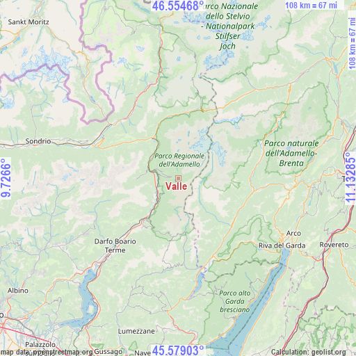
| Upper-left | 46.55468°, | 9.7266° |
| Center: | 46.06901°, | 10.42972° |
| Lower-right: | 45.57903°, | 11.13285° |
| Map W x H: | 108.5×108.5 km | = 67.4×67.4mi |
| max Lat: | 47.04031° ⇑6.6% North |
| Valle: | 46.06901° |
| min Lat: | ⇓93.4% South 35.50142° |
| min Long | Valle | max Long |
| 6.69888° | 10.42972° | 18.48682° |
| W 36.4%⇐ | ⇒63.6% E |
Elevation
Elevation of Valle is 1118 m = 3668 ft, and this is 811.3 m = 2662 ft above average elevation for this country.
| Max E: |
2085 m = 6841 ft | 1.9% |
| Valle | 1118 m 3668 ft | |
| Avg. | 306.7 m = 1006 ft | |
Min E: |
-4 m = -13 ft | 98.1% |
See also: Italy elevation on elevation.city.
Geographical zone
Valle is located in North temperate zone (between Tropic of Cancer and the Arctic Circle). Distance of this North polar circle is 2278.8 km =1416 mi to North.| Distance of | km | miles | from Valle |
|---|---|---|---|
| North Pole | 4884.7 | 3035.2 | to North |
| Arctic Circle | 2278.8 | 1416 | to North |
| Tropic Cancer | 2516.5 | 1563.7 | to South |
| Equator | 5122.4 | 3182.9 | to South |


Nearby cities:
15 places around Valle: (largest is in red/bold)
• Badetto
10.5 km =6.5 mi,  219°
219°
• Berzo
7.9 km =4.9 mi,  289°
289°
• Capo di Ponte
8 km =5 mi,  237°
237°
• Cedegolo
6.1 km =3.8 mi,  275°
275°
• Cerveno
10.8 km =6.7 mi,  226°
226°
• Ceto
9.5 km =5.9 mi, 219°
• Cevo
4.8 km =3 mi, 285°
• Cimbergo
7 km =4.3 mi, 224°
• Demo
7.2 km =4.5 mi, 286°
• Malonno
10.4 km =6.5 mi,  304°
304°
• Ono San Pietro
9.7 km =6 mi, 233°
• Paisco Loveno
10.6 km =6.6 mi, 276°
• Paspardo
6.2 km =3.9 mi, 228°
• Saviore
2.7 km =1.7 mi, 297°
• Sellero
6.6 km =4.1 mi,  252°
252°
Sources, notices
• [Note1] Compared only with cities in Italy existing in our database
• [Src1] Map data: © OpenStreetMap contributors (CC-BY-SA)
• [Src2] Other city data from geonames.org with taken over terms of usage.
• [Src3] Geographical zone / Annual Mean Temperature by Robert A. Rohde @ Wikipedia
