Paspardo geodata
Paspardo (Lombardy) is a seat of a third-order administrative division; located in Italy in Europe/Rome (GMT+2) time zone. With population of 646 people, there are 8661 cities with bigger population in this country. Compared to other cities in Italy, 92.6% of cities are located further ↓South; 64.3% of cities are located further →East and 96.6% of cities have lower elevation than Paspardo. Note1


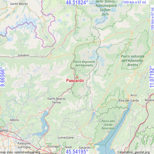
Paspardo GPS coordinates[2]
46° 1' 56.1" North, 10° 22' 7.644" East
| Map corner | latitude | longitude |
|---|---|---|
| Upper-left | 46.51824°, | 9.66566° |
| Center: | 46.03225°, | 10.36879° |
| Lower-right: | 45.54195°, | 11.07192° |
| Map W x H: | 108.6×108.6 km | = 67.5×67.5mi |
| max Lat: | 47.04031° ⇑7.4% North |
| Paspardo: | 46.03225° |
| min Lat: | ⇓92.6% South 35.50142° |
| min Long | Paspardo | max Long |
| 6.69888° | 10.36879° | 18.48682° |
| W 35.7%⇐ | ⇒64.3% E |
Elevation
Elevation of Paspardo is 976 m = 3202 ft, and this is 669.3 m = 2196 ft above average elevation for this country.
| Max E: |
2085 m = 6841 ft | 3.4% |
| Paspardo | 976 m 3202 ft | |
| Avg. | 306.7 m = 1006 ft | |
Min E: |
-4 m = -13 ft | 96.6% |
See also: Italy elevation on elevation.city.
Geographical zone
Paspardo is located in North temperate zone (between Tropic of Cancer and the Arctic Circle). Distance of this North polar circle is 2282.9 km =1418.5 mi to North.| Distance of | km | miles | from Paspardo |
|---|---|---|---|
| North Pole | 4888.8 | 3037.8 | to North |
| Arctic Circle | 2282.9 | 1418.5 | to North |
| Tropic Cancer | 2512.4 | 1561.1 | to South |
| Equator | 5118.3 | 3180.4 | to South |


Nearby cities:
15 places around Paspardo: (largest is in red/bold)
• Badetto
4.4 km =2.7 mi,  206°
206°
• Braone
5.1 km =3.2 mi,  203°
203°
• Capo di Ponte
2 km =1.2 mi,  262°
262°
• Cedegolo
4.8 km =3 mi,  343°
343°
• Cerveno
4.6 km =2.9 mi,  222°
222°
• Ceto
3.5 km =2.2 mi, 201°
• Cevo
5.4 km =3.4 mi,  0°
0°
• Cimbergo
0.9 km =0.6 mi,  194°
194°
• Demo
6.5 km =4 mi, 340°
• Losine
6.8 km =4.2 mi, 216°
• Niardo
6.8 km =4.2 mi, 203°
• Ono San Pietro
3.6 km =2.2 mi,  241°
241°
• Saviore
5.8 km =3.6 mi,  22°
22°
• Sellero
2.7 km =1.7 mi,  322°
322°
• Valle
6.2 km =3.9 mi,  48°
48°
Sources, notices
• [Note1] Compared only with cities in Italy existing in our database
• [Src1] Map data: © OpenStreetMap contributors (CC-BY-SA)
• [Src2] Other city data from geonames.org with taken over terms of usage.
• [Src3] Geographical zone / Annual Mean Temperature by Robert A. Rohde @ Wikipedia
