Valgrana geodata
Valgrana (Piedmont) is a seat of a third-order administrative division; located in Italy in Europe/Rome (GMT+2) time zone. With population of 375 people, there are 10375 cities with bigger population in this country. Compared to other cities in Italy, 50.3% of cities are located further ↑North; 98.5% of cities are located further →East and 86.3% of cities have lower elevation than Valgrana. Note1


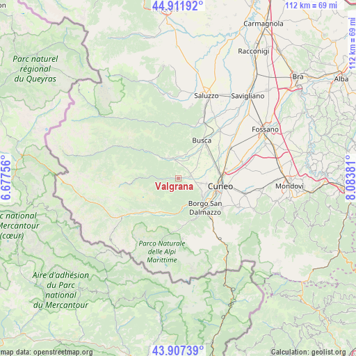
Valgrana GPS coordinates[2]
44° 24' 42.516" North, 7° 22' 50.448" East
| Map corner | latitude | longitude |
|---|---|---|
| Upper-left | 44.91192°, | 6.67756° |
| Center: | 44.41181°, | 7.38068° |
| Lower-right: | 43.90739°, | 8.08381° |
| Map W x H: | 111.7×111.7 km | = 69.4×69.4mi |
| max Lat: | 47.04031° ⇑50.3% North |
| Valgrana: | 44.41181° |
| min Lat: | ⇓49.7% South 35.50142° |
| min Long | Valgrana | max Long |
| 6.69888° | 7.38068° | 18.48682° |
| W 1.5%⇐ | ⇒98.5% E |
Elevation
Elevation of Valgrana is 639 m = 2096 ft, and this is 332.3 m = 1090 ft above average elevation for this country.
| Max E: |
2085 m = 6841 ft | 13.7% |
| Valgrana | 639 m 2096 ft | |
| Avg. | 306.7 m = 1006 ft | |
Min E: |
-4 m = -13 ft | 86.3% |
See also: Italy elevation on elevation.city.
Geographical zone
Valgrana is located in North temperate zone (between Tropic of Cancer and the Arctic Circle). Distance of this Northern Tropic circle is 2332.2 km =1449.2 mi to South.| Distance of | km | miles | from Valgrana |
|---|---|---|---|
| North Pole | 5068.9 | 3149.7 | to North |
| Arctic Circle | 2463 | 1530.4 | to North |
| Tropic Cancer | 2332.2 | 1449.2 | to South |
| Equator | 4938.1 | 3068.4 | to South |


Nearby cities:
15 places around Valgrana: (largest is in red/bold)
• Bernezzo
5.3 km =3.3 mi,  123°
123°
• Caraglio
4.2 km =2.6 mi,  81°
81°
• Cervasca
8 km =5 mi, 115°
• Dronero
6.1 km =3.8 mi,  346°
346°
• Gaiola
8.8 km =5.5 mi,  165°
165°
• Montemale di Cuneo
2.9 km =1.8 mi, 351°
• Monterosso Grana
4.6 km =2.9 mi,  265°
265°
• Pradleves
7.9 km =4.9 mi, 274°
• Rittana
6.9 km =4.3 mi, 168°
• Roccabruna
7.6 km =4.7 mi,  337°
337°
• San Rocco
7.5 km =4.7 mi,  103°
103°
• Tettorosso
7.4 km =4.6 mi, 336°
• Valloriate
8.3 km =5.2 mi,  183°
183°
• Vignolo
9 km =5.6 mi,  126°
126°
• Villar San Costanzo
8.1 km =5 mi,  0°
0°
Sources, notices
• [Note1] Compared only with cities in Italy existing in our database
• [Src1] Map data: © OpenStreetMap contributors (CC-BY-SA)
• [Src2] Other city data from geonames.org with taken over terms of usage.
• [Src3] Geographical zone / Annual Mean Temperature by Robert A. Rohde @ Wikipedia
