Valloriate geodata
Valloriate (Piedmont) is a seat of a third-order administrative division; located in Italy in Europe/Rome (GMT+2) time zone. With population of 166 people, there are 11231 cities with bigger population in this country. Compared to other cities in Italy, 51.4% of cities are located further ↑North; 98.5% of cities are located further →East and 92.5% of cities have lower elevation than Valloriate. Note1


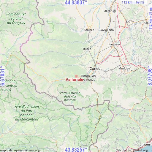
Valloriate GPS coordinates[2]
44° 20' 15.468" North, 7° 22' 26.148" East
| Map corner | latitude | longitude |
|---|---|---|
| Upper-left | 44.83837°, | 6.67081° |
| Center: | 44.33763°, | 7.37393° |
| Lower-right: | 43.83257°, | 8.07706° |
| Map W x H: | 111.8×111.8 km | = 69.5×69.5mi |
| max Lat: | 47.04031° ⇑51.4% North |
| Valloriate: | 44.33763° |
| min Lat: | ⇓48.6% South 35.50142° |
| min Long | Valloriate | max Long |
| 6.69888° | 7.37393° | 18.48682° |
| W 1.5%⇐ | ⇒98.5% E |
Elevation
Elevation of Valloriate is 785 m = 2575 ft, and this is 478.3 m = 1569 ft above average elevation for this country.
| Max E: |
2085 m = 6841 ft | 7.5% |
| Valloriate | 785 m 2575 ft | |
| Avg. | 306.7 m = 1006 ft | |
Min E: |
-4 m = -13 ft | 92.5% |
See also: Italy elevation on elevation.city.
Geographical zone
Valloriate is located in North temperate zone (between Tropic of Cancer and the Arctic Circle). Distance of this Northern Tropic circle is 2324 km =1444.1 mi to South.| Distance of | km | miles | from Valloriate |
|---|---|---|---|
| North Pole | 5077.2 | 3154.8 | to North |
| Arctic Circle | 2471.3 | 1535.6 | to North |
| Tropic Cancer | 2324 | 1444.1 | to South |
| Equator | 4929.9 | 3063.3 | to South |


Nearby cities:
15 places around Valloriate: (largest is in red/bold)
• Bernezzo
7.3 km =4.5 mi,  43°
43°
• Borgo San Dalmazzo
9.5 km =5.9 mi,  89°
89°
• Caraglio
10 km =6.2 mi,  27°
27°
• Cervasca
9.1 km =5.7 mi,  58°
58°
• Demonte
6.5 km =4 mi,  248°
248°
• Gaiola
2.8 km =1.7 mi, 94°
• Moiola
2.2 km =1.4 mi,  145°
145°
• Monterosso Grana
8.8 km =5.5 mi,  332°
332°
• Rittana
2.5 km =1.6 mi,  52°
52°
• Roaschia
9.9 km =6.2 mi,  139°
139°
• Roccasparvera
5.4 km =3.4 mi,  84°
84°
• Roccavione
8.7 km =5.4 mi,  107°
107°
• Valdieri
6.9 km =4.3 mi,  164°
164°
• Valgrana
8.3 km =5.2 mi,  3°
3°
• Vignolo
8.3 km =5.2 mi,  69°
69°
Sources, notices
• [Note1] Compared only with cities in Italy existing in our database
• [Src1] Map data: © OpenStreetMap contributors (CC-BY-SA)
• [Src2] Other city data from geonames.org with taken over terms of usage.
• [Src3] Geographical zone / Annual Mean Temperature by Robert A. Rohde @ Wikipedia
