Ururi geodata
Ururi (Molise) is a seat of a third-order administrative division; located in Italy in Europe/Rome (GMT+2) time zone. With population of 2,565 people, there are 3444 cities with bigger population in this country. Compared to other cities in Italy, 71.9% of cities are located further ↑North; 87.3% of cities are located further ←West and 52.8% of cities have lower elevation than Ururi. Note1


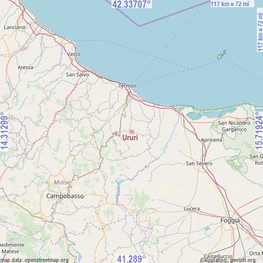
Ururi GPS coordinates[2]
41° 48' 54.648" North, 15° 0' 57.996" East
| Map corner | latitude | longitude |
|---|---|---|
| Upper-left | 42.33707°, | 14.31299° |
| Center: | 41.81518°, | 15.01611° |
| Lower-right: | 41.289°, | 15.71924° |
| Map W x H: | 116.5×116.5 km | = 72.4×72.4mi |
| max Lat: | 47.04031° ⇑71.9% North |
| Ururi: | 41.81518° |
| min Lat: | ⇓28.1% South 35.50142° |
| min Long | Ururi | max Long |
| 6.69888° | 15.01611° | 18.48682° |
| W 87.3%⇐ | ⇒12.7% E |
Elevation
Elevation of Ururi is 252 m = 827 ft, and this is 54.7 m = 179 ft below average elevation for this country.
| Max E: |
2085 m = 6841 ft | 47.2% |
| Avg. | 306.7 m = 1006 ft | |
| Ururi | 252 m = 827 ft | |
Min E: |
-4 m = -13 ft | 52.8% |
See also: Italy elevation on elevation.city.
Geographical zone
Ururi is located in North temperate zone (between Tropic of Cancer and the Arctic Circle). Distance of this Northern Tropic circle is 2043.5 km =1269.8 mi to South.| Distance of | km | miles | from Ururi |
|---|---|---|---|
| North Pole | 5357.6 | 3329.1 | to North |
| Arctic Circle | 2751.8 | 1709.9 | to North |
| Tropic Cancer | 2043.5 | 1269.8 | to South |
| Equator | 4649.4 | 2889 | to South |


Nearby cities:
15 places around Ururi: (largest is in red/bold)
• Bonefro
14 km =8.7 mi,  208°
208°
• Campomarino
15.8 km =9.8 mi,  5°
5°
• Casacalenda
16.4 km =10.2 mi,  238°
238°
• Chieuti
12.9 km =8 mi,  75°
75°
• Guglionesi
14.4 km =8.9 mi,  324°
324°
• Larino
8.2 km =5.1 mi,  261°
261°
• Lido Campomarino
16.1 km =10 mi, 10°
• Montelongo
10.3 km =6.4 mi, 212°
• Montorio Nei Frentani
9.3 km =5.8 mi,  227°
227°
• Portocannone
11.1 km =6.9 mi,  356°
356°
• Rotello
7.5 km =4.7 mi,  186°
186°
• San Giuliano di Puglia
14.8 km =9.2 mi,  197°
197°
• San Martino in Pensilis
7 km =4.3 mi,  1°
1°
• Santa Croce di Magliano
11.7 km =7.3 mi, 191°
• Serracapriola
12 km =7.5 mi,  93°
93°
Sources, notices
• [Note1] Compared only with cities in Italy existing in our database
• [Src1] Map data: © OpenStreetMap contributors (CC-BY-SA)
• [Src2] Other city data from geonames.org with taken over terms of usage.
• [Src3] Geographical zone / Annual Mean Temperature by Robert A. Rohde @ Wikipedia
