Rotello geodata
Rotello (Molise) is a seat of a third-order administrative division; located in Italy in Europe/Rome (GMT+2) time zone. With population of 1,072 people, there are 6395 cities with bigger population in this country. Compared to other cities in Italy, 72.4% of cities are located further ↑North; 87.2% of cities are located further ←West and 66.9% of cities have lower elevation than Rotello. Note1


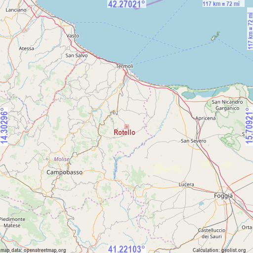
Rotello GPS coordinates[2]
41° 44' 51.936" North, 15° 0' 21.888" East
| Map corner | latitude | longitude |
|---|---|---|
| Upper-left | 42.27021°, | 14.30296° |
| Center: | 41.74776°, | 15.00608° |
| Lower-right: | 41.22103°, | 15.70921° |
| Map W x H: | 116.7×116.7 km | = 72.5×72.5mi |
| max Lat: | 47.04031° ⇑72.4% North |
| Rotello: | 41.74776° |
| min Lat: | ⇓27.6% South 35.50142° |
| min Long | Rotello | max Long |
| 6.69888° | 15.00608° | 18.48682° |
| W 87.2%⇐ | ⇒12.8% E |
Elevation
Elevation of Rotello is 362 m = 1188 ft, and this is 55.3 m = 181 ft above average elevation for this country.
| Max E: |
2085 m = 6841 ft | 33.1% |
| Rotello | 362 m 1188 ft | |
| Avg. | 306.7 m = 1006 ft | |
Min E: |
-4 m = -13 ft | 66.9% |
See also: Italy elevation on elevation.city.
Geographical zone
Rotello is located in North temperate zone (between Tropic of Cancer and the Arctic Circle). Distance of this Northern Tropic circle is 2036 km =1265.1 mi to South.| Distance of | km | miles | from Rotello |
|---|---|---|---|
| North Pole | 5365.1 | 3333.7 | to North |
| Arctic Circle | 2759.3 | 1714.5 | to North |
| Tropic Cancer | 2036 | 1265.1 | to South |
| Equator | 4641.9 | 2884.3 | to South |


Nearby cities:
15 places around Rotello: (largest is in red/bold)
• Bonefro
7.6 km =4.7 mi,  231°
231°
• Carlantino
17.3 km =10.7 mi,  188°
188°
• Casacalenda
13.2 km =8.2 mi,  265°
265°
• Casalnuovo Monterotaro
16.4 km =10.2 mi,  150°
150°
• Chieuti
17.1 km =10.6 mi,  50°
50°
• Colletorto
10.1 km =6.3 mi,  198°
198°
• Larino
9.6 km =6 mi,  310°
310°
• Montelongo
4.8 km =3 mi,  255°
255°
• Montorio Nei Frentani
6.2 km =3.9 mi,  281°
281°
• Provvidenti
15.5 km =9.6 mi, 257°
• San Giuliano di Puglia
7.6 km =4.7 mi,  208°
208°
• San Martino in Pensilis
14.5 km =9 mi,  3°
3°
• Santa Croce di Magliano
4.2 km =2.6 mi, 201°
• Serracapriola
14.5 km =9 mi,  62°
62°
• Ururi
7.5 km =4.7 mi,  6°
6°
Sources, notices
• [Note1] Compared only with cities in Italy existing in our database
• [Src1] Map data: © OpenStreetMap contributors (CC-BY-SA)
• [Src2] Other city data from geonames.org with taken over terms of usage.
• [Src3] Geographical zone / Annual Mean Temperature by Robert A. Rohde @ Wikipedia
