Urbino geodata
Urbino (The Marches) is a seat of a third-order administrative division; located in Italy in Europe/Rome (GMT+2) time zone. With population of 5,858 people, there are 1675 cities with bigger population in this country. Compared to other cities in Italy, 57.8% of cities are located further ↑North; 64.1% of cities are located further ←West and 74.6% of cities have lower elevation than Urbino. Note1
Administrative division(s):
- Level 1: The Marches
- Level 2: Provincia di Pesaro e Urbino
- Level 3: Urbino


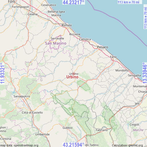
Urbino GPS coordinates[2]
43° 43' 34.356" North, 12° 38' 10.788" East
| Map corner | latitude | longitude |
|---|---|---|
| Upper-left | 44.23217°, | 11.93321° |
| Center: | 43.72621°, | 12.63633° |
| Lower-right: | 43.21594°, | 13.33946° |
| Map W x H: | 113×113 km | = 70.2×70.2mi |
| max Lat: | 47.04031° ⇑57.8% North |
| Urbino: | 43.72621° |
| min Lat: | ⇓42.2% South 35.50142° |
| min Long | Urbino | max Long |
| 6.69888° | 12.63633° | 18.48682° |
| W 64.1%⇐ | ⇒35.9% E |
Elevation
Elevation of Urbino is 447 m = 1467 ft, and this is 140.3 m = 460 ft above average elevation for this country.
| Max E: |
2085 m = 6841 ft | 25.4% |
| Urbino | 447 m 1467 ft | |
| Avg. | 306.7 m = 1006 ft | |
Min E: |
-4 m = -13 ft | 74.6% |
See also: Italy elevation on elevation.city.
Geographical zone
Urbino is located in North temperate zone (between Tropic of Cancer and the Arctic Circle). Distance of this Northern Tropic circle is 2256 km =1401.8 mi to South.| Distance of | km | miles | from Urbino |
|---|---|---|---|
| North Pole | 5145.2 | 3197.1 | to North |
| Arctic Circle | 2539.3 | 1577.8 | to North |
| Tropic Cancer | 2256 | 1401.8 | to South |
| Equator | 4861.9 | 3021 | to South |


Nearby cities:
15 places around Urbino: (largest is in red/bold)
• Acqualagna
11.6 km =7.2 mi,  164°
164°
• Auditore
11.8 km =7.3 mi,  333°
333°
• Borgo Massano
11.5 km =7.1 mi,  17°
17°
• Ca' Gallo
8.3 km =5.2 mi,  351°
351°
• Canavaccio
6.2 km =3.9 mi,  125°
125°
• Casinina
10.9 km =6.8 mi,  337°
337°
• Fermignano
4 km =2.5 mi, 158°
• Gadana
2.8 km =1.7 mi, 335°
• Gallo
9.1 km =5.7 mi,  42°
42°
• Montecalvo in Foglia
9.4 km =5.8 mi,  357°
357°
• Peglio
11.6 km =7.2 mi,  253°
253°
• Petriano
9.7 km =6 mi,  52°
52°
• Ponte Armellina Zona Residenziale
8.6 km =5.3 mi, 45°
• Trasanni
3.8 km =2.4 mi, 35°
• Urbania
11.3 km =7 mi,  235°
235°
Sources, notices
• [Note1] Compared only with cities in Italy existing in our database
• [Src1] Map data: © OpenStreetMap contributors (CC-BY-SA)
• [Src2] Other city data from geonames.org with taken over terms of usage.
• [Src3] Geographical zone / Annual Mean Temperature by Robert A. Rohde @ Wikipedia
