Tuglie geodata
Tuglie (Apulia) is a seat of a third-order administrative division; located in Italy in Europe/Rome (GMT+2) time zone. With population of 5,100 people, there are 1921 cities with bigger population in this country. Compared to other cities in Italy, 87.4% of cities are located further ↑North; 99.1% of cities are located further ←West and 72% of cities have higher elevation than Tuglie. Note1


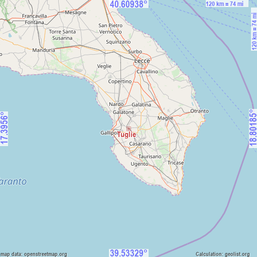
Tuglie GPS coordinates[2]
40° 4' 24.456" North, 18° 5' 55.392" East
| Map corner | latitude | longitude |
|---|---|---|
| Upper-left | 40.60938°, | 17.3956° |
| Center: | 40.07346°, | 18.09872° |
| Lower-right: | 39.53329°, | 18.80185° |
| Map W x H: | 119.6×119.6 km | = 74.3×74.3mi |
| max Lat: | 47.04031° ⇑87.4% North |
| Tuglie: | 40.07346° |
| min Lat: | ⇓12.6% South 35.50142° |
| min Long | Tuglie | max Long |
| 6.69888° | 18.09872° | 18.48682° |
| W 99.1%⇐ | ⇒0.90000000000001% E |
Elevation
Elevation of Tuglie is 88 m = 289 ft, and this is 218.7 m = 718 ft below average elevation for this country.
| Max E: |
2085 m = 6841 ft | 72% |
| Avg. | 306.7 m = 1006 ft | |
| Tuglie | 88 m = 289 ft | |
Min E: |
-4 m = -13 ft | 28% |
See also: Italy elevation on elevation.city.
Geographical zone
Tuglie is located in North temperate zone (between Tropic of Cancer and the Arctic Circle). Distance of this Northern Tropic circle is 1849.8 km =1149.4 mi to South.| Distance of | km | miles | from Tuglie |
|---|---|---|---|
| North Pole | 5551.3 | 3449.4 | to North |
| Arctic Circle | 2945.4 | 1830.2 | to North |
| Tropic Cancer | 1849.8 | 1149.4 | to South |
| Equator | 4455.8 | 2768.7 | to South |


Nearby cities:
15 places around Tuglie: (largest is in red/bold)
• Alezio
3.8 km =2.4 mi,  250°
250°
• Aradeo
6.7 km =4.2 mi,  22°
22°
• Casarano
8.8 km =5.5 mi,  141°
141°
• Chiesanuova
4 km =2.5 mi,  292°
292°
• Collepasso
5.4 km =3.4 mi,  92°
92°
• Cutrofiano
10.6 km =6.6 mi,  56°
56°
• Galatone
8.5 km =5.3 mi,  342°
342°
• Gallipoli
9.4 km =5.8 mi,  258°
258°
• Matino
5.7 km =3.5 mi,  145°
145°
• Neviano
3.9 km =2.4 mi, 20°
• Noha
10.5 km =6.5 mi,  32°
32°
• Parabita
3.4 km =2.1 mi, 136°
• Sannicola
3.4 km =2.1 mi,  308°
308°
• Seclì
5.1 km =3.2 mi,  10°
10°
• Taviano
10.2 km =6.3 mi,  188°
188°
Sources, notices
• [Note1] Compared only with cities in Italy existing in our database
• [Src1] Map data: © OpenStreetMap contributors (CC-BY-SA)
• [Src2] Other city data from geonames.org with taken over terms of usage.
• [Src3] Geographical zone / Annual Mean Temperature by Robert A. Rohde @ Wikipedia
