Collepasso geodata
Collepasso (Apulia) is a seat of a third-order administrative division; located in Italy in Europe/Rome (GMT+2) time zone. With population of 6,178 people, there are 1586 cities with bigger population in this country. Compared to other cities in Italy, 87.4% of cities are located further ↑North; 99.2% of cities are located further ←West and 66% of cities have higher elevation than Collepasso. Note1


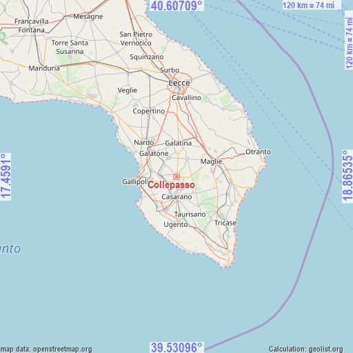
Collepasso GPS coordinates[2]
40° 4' 16.14" North, 18° 9' 43.992" East
| Map corner | latitude | longitude |
|---|---|---|
| Upper-left | 40.60709°, | 17.4591° |
| Center: | 40.07115°, | 18.16222° |
| Lower-right: | 39.53096°, | 18.86535° |
| Map W x H: | 119.7×119.7 km | = 74.4×74.4mi |
| max Lat: | 47.04031° ⇑87.4% North |
| Collepasso: | 40.07115° |
| min Lat: | ⇓12.6% South 35.50142° |
| min Long | Collepasso | max Long |
| 6.69888° | 18.16222° | 18.48682° |
| W 99.2%⇐ | ⇒0.8% E |
Elevation
Elevation of Collepasso is 121 m = 397 ft, and this is 185.7 m = 609 ft below average elevation for this country.
| Max E: |
2085 m = 6841 ft | 66% |
| Avg. | 306.7 m = 1006 ft | |
| Collepasso | 121 m = 397 ft | |
Min E: |
-4 m = -13 ft | 34% |
See also: Italy elevation on elevation.city.
Geographical zone
Collepasso is located in North temperate zone (between Tropic of Cancer and the Arctic Circle). Distance of this Northern Tropic circle is 1849.6 km =1149.3 mi to South.| Distance of | km | miles | from Collepasso |
|---|---|---|---|
| North Pole | 5551.6 | 3449.6 | to North |
| Arctic Circle | 2945.7 | 1830.4 | to North |
| Tropic Cancer | 1849.6 | 1149.3 | to South |
| Equator | 4455.5 | 2768.5 | to South |


Nearby cities:
15 places around Collepasso: (largest is in red/bold)
• Alezio
9 km =5.6 mi,  263°
263°
• Aradeo
7 km =4.3 mi,  336°
336°
• Casarano
6.7 km =4.2 mi,  179°
179°
• Chiesanuova
9.3 km =5.8 mi,  281°
281°
• Cutrofiano
7 km =4.3 mi,  29°
29°
• Matino
5 km =3.1 mi,  206°
206°
• Melissano
11.4 km =7.1 mi,  197°
197°
• Neviano
5.6 km =3.5 mi,  314°
314°
• Noha
9.1 km =5.7 mi,  1°
1°
• Parabita
3.7 km =2.3 mi,  234°
234°
• Sannicola
8.4 km =5.2 mi,  286°
286°
• Seclì
7 km =4.3 mi,  319°
319°
• Sogliano Cavour
9.1 km =5.7 mi,  19°
19°
• Supersano
9.1 km =5.7 mi,  131°
131°
• Tuglie
5.4 km =3.4 mi,  272°
272°
Sources, notices
• [Note1] Compared only with cities in Italy existing in our database
• [Src1] Map data: © OpenStreetMap contributors (CC-BY-SA)
• [Src2] Other city data from geonames.org with taken over terms of usage.
• [Src3] Geographical zone / Annual Mean Temperature by Robert A. Rohde @ Wikipedia
