Trofarello geodata
Trofarello (Piedmont) is a seat of a third-order administrative division; located in Italy in Europe/Rome (GMT+2) time zone. With population of 10,763 people, there are 883 cities with bigger population in this country. Compared to other cities in Italy, 59.5% of cities are located further ↓South; 96% of cities are located further →East and 52.5% of cities have lower elevation than Trofarello. Note1


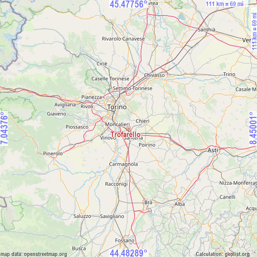
Trofarello GPS coordinates[2]
44° 58' 56.568" North, 7° 44' 48.768" East
| Map corner | latitude | longitude |
|---|---|---|
| Upper-left | 45.47756°, | 7.04376° |
| Center: | 44.98238°, | 7.74688° |
| Lower-right: | 44.48289°, | 8.45001° |
| Map W x H: | 110.6×110.6 km | = 68.7×68.7mi |
| max Lat: | 47.04031° ⇑40.5% North |
| Trofarello: | 44.98238° |
| min Lat: | ⇓59.5% South 35.50142° |
| min Long | Trofarello | max Long |
| 6.69888° | 7.74688° | 18.48682° |
| W 4%⇐ | ⇒96% E |
Elevation
Elevation of Trofarello is 250 m = 820 ft, and this is 56.7 m = 186 ft below average elevation for this country.
| Max E: |
2085 m = 6841 ft | 47.5% |
| Avg. | 306.7 m = 1006 ft | |
| Trofarello | 250 m = 820 ft | |
Min E: |
-4 m = -13 ft | 52.5% |
See also: Italy elevation on elevation.city.
Geographical zone
Trofarello is located in North temperate zone (between Tropic of Cancer and the Arctic Circle). Distance of this Northern Tropic circle is 2395.7 km =1488.6 mi to South.| Distance of | km | miles | from Trofarello |
|---|---|---|---|
| North Pole | 5005.5 | 3110.3 | to North |
| Arctic Circle | 2399.6 | 1491 | to North |
| Tropic Cancer | 2395.7 | 1488.6 | to South |
| Equator | 5001.6 | 3107.8 | to South |


Nearby cities:
15 places around Trofarello: (largest is in red/bold)
• Cambiano
2.5 km =1.6 mi,  119°
119°
• Chieri
6.6 km =4.1 mi,  61°
61°
• Favari-Avatanei
8.8 km =5.5 mi,  151°
151°
• La Loggia
6.9 km =4.3 mi,  243°
243°
• Marocchi
7.2 km =4.5 mi,  128°
128°
• Moncalieri
5.4 km =3.4 mi,  290°
290°
• Nichelino
7.6 km =4.7 mi, 285°
• Pecetto
3.9 km =2.4 mi,  4°
4°
• Pessione
7.7 km =4.8 mi,  104°
104°
• Pino Torinese
6.8 km =4.2 mi,  20°
20°
• Revigliasco
3.9 km =2.4 mi,  343°
343°
• San Pietro
2.9 km =1.8 mi,  28°
28°
• Santena
4.5 km =2.8 mi, 152°
• Tagliaferro
6.5 km =4 mi,  266°
266°
• Villastellone
6.7 km =4.2 mi,  182°
182°
Sources, notices
• [Note1] Compared only with cities in Italy existing in our database
• [Src1] Map data: © OpenStreetMap contributors (CC-BY-SA)
• [Src2] Other city data from geonames.org with taken over terms of usage.
• [Src3] Geographical zone / Annual Mean Temperature by Robert A. Rohde @ Wikipedia
