Santena geodata
Santena (Piedmont) is a seat of a third-order administrative division; located in Italy in Europe/Rome (GMT+2) time zone. With population of 10,437 people, there are 905 cities with bigger population in this country. Compared to other cities in Italy, 58.8% of cities are located further ↓South; 95.8% of cities are located further →East and 50.2% of cities have lower elevation than Santena. Note1


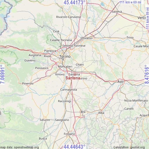
Santena GPS coordinates[2]
44° 56' 46.464" North, 7° 46' 22.908" East
| Map corner | latitude | longitude |
|---|---|---|
| Upper-left | 45.44173°, | 7.06991° |
| Center: | 44.94624°, | 7.77303° |
| Lower-right: | 44.44643°, | 8.47616° |
| Map W x H: | 110.7×110.7 km | = 68.8×68.8mi |
| max Lat: | 47.04031° ⇑41.2% North |
| Santena: | 44.94624° |
| min Lat: | ⇓58.8% South 35.50142° |
| min Long | Santena | max Long |
| 6.69888° | 7.77303° | 18.48682° |
| W 4.2%⇐ | ⇒95.8% E |
Elevation
Elevation of Santena is 236 m = 774 ft, and this is 70.7 m = 232 ft below average elevation for this country.
| Max E: |
2085 m = 6841 ft | 49.8% |
| Avg. | 306.7 m = 1006 ft | |
| Santena | 236 m = 774 ft | |
Min E: |
-4 m = -13 ft | 50.2% |
See also: Italy elevation on elevation.city.
Geographical zone
Santena is located in North temperate zone (between Tropic of Cancer and the Arctic Circle). Distance of this Northern Tropic circle is 2391.6 km =1486.1 mi to South.| Distance of | km | miles | from Santena |
|---|---|---|---|
| North Pole | 5009.5 | 3112.8 | to North |
| Arctic Circle | 2403.6 | 1493.5 | to North |
| Tropic Cancer | 2391.6 | 1486.1 | to South |
| Equator | 4997.6 | 3105.4 | to South |


Nearby cities:
15 places around Santena: (largest is in red/bold)
• Cambiano
2.8 km =1.7 mi,  2°
2°
• Carignano
9.1 km =5.7 mi,  240°
240°
• Chieri
8.1 km =5 mi,  27°
27°
• Favari-Avatanei
4.3 km =2.7 mi,  151°
151°
• La Loggia
8.3 km =5.2 mi,  276°
276°
• Marocchi
3.6 km =2.2 mi,  97°
97°
• Pecetto
8.1 km =5 mi,  347°
347°
• Pessione
5.8 km =3.6 mi,  68°
68°
• Poirino
6.3 km =3.9 mi,  116°
116°
• Revigliasco
8.4 km =5.2 mi,  337°
337°
• Riva Presso Chieri
8.9 km =5.5 mi,  62°
62°
• San Pietro
6.6 km =4.1 mi, 354°
• Tagliaferro
9.3 km =5.8 mi,  292°
292°
• Trofarello
4.5 km =2.8 mi,  332°
332°
• Villastellone
3.6 km =2.2 mi,  220°
220°
Sources, notices
• [Note1] Compared only with cities in Italy existing in our database
• [Src1] Map data: © OpenStreetMap contributors (CC-BY-SA)
• [Src2] Other city data from geonames.org with taken over terms of usage.
• [Src3] Geographical zone / Annual Mean Temperature by Robert A. Rohde @ Wikipedia
