Revigliasco geodata
Revigliasco (Piedmont) is a populated place; located in Italy in Europe/Rome (GMT+2) time zone. With population of 2,265 people, there are 3801 cities with bigger population in this country. Compared to other cities in Italy, 60.4% of cities are located further ↓South; 96.1% of cities are located further →East and 63.8% of cities have lower elevation than Revigliasco. Note1


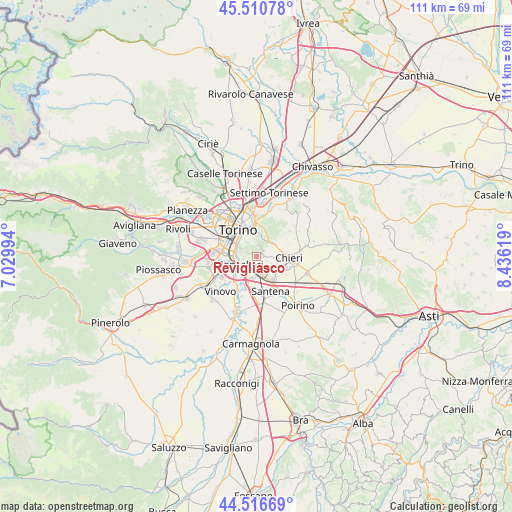
Revigliasco GPS coordinates[2]
45° 0' 57.204" North, 7° 43' 59.016" East
| Map corner | latitude | longitude |
|---|---|---|
| Upper-left | 45.51078°, | 7.02994° |
| Center: | 45.01589°, | 7.73306° |
| Lower-right: | 44.51669°, | 8.43619° |
| Map W x H: | 110.5×110.5 km | = 68.7×68.7mi |
| max Lat: | 47.04031° ⇑39.6% North |
| Revigliasco: | 45.01589° |
| min Lat: | ⇓60.4% South 35.50142° |
| min Long | Revigliasco | max Long |
| 6.69888° | 7.73306° | 18.48682° |
| W 3.9%⇐ | ⇒96.1% E |
Elevation
Elevation of Revigliasco is 332 m = 1089 ft, and this is 25.3 m = 83 ft above average elevation for this country.
| Max E: |
2085 m = 6841 ft | 36.2% |
| Revigliasco | 332 m 1089 ft | |
| Avg. | 306.7 m = 1006 ft | |
Min E: |
-4 m = -13 ft | 63.8% |
See also: Italy elevation on elevation.city.
Geographical zone
Revigliasco is located in North temperate zone (between Tropic of Cancer and the Arctic Circle). Distance of this North polar circle is 2395.9 km =1488.7 mi to North.| Distance of | km | miles | from Revigliasco |
|---|---|---|---|
| North Pole | 5001.8 | 3108 | to North |
| Arctic Circle | 2395.9 | 1488.7 | to North |
| Tropic Cancer | 2399.4 | 1490.9 | to South |
| Equator | 5005.3 | 3110.1 | to South |


Nearby cities:
15 places around Revigliasco: (largest is in red/bold)
• Baldissero Torinese
8.6 km =5.3 mi,  47°
47°
• Cambiano
5.9 km =3.7 mi,  146°
146°
• Chieri
7 km =4.3 mi,  94°
94°
• Gerbido
9.9 km =6.2 mi,  288°
288°
• La Loggia
8.5 km =5.3 mi,  216°
216°
• Lesna
9.8 km =6.1 mi,  295°
295°
• Moncalieri
4.4 km =2.7 mi,  245°
245°
• Nichelino
6.5 km =4 mi, 254°
• Pecetto
1.4 km =0.9 mi,  82°
82°
• Pino Torinese
4.3 km =2.7 mi, 52°
• San Pietro
2.7 km =1.7 mi,  115°
115°
• Santena
8.4 km =5.2 mi,  157°
157°
• Tagliaferro
6.8 km =4.2 mi,  232°
232°
• Trofarello
3.9 km =2.4 mi, 163°
• Turin
7.1 km =4.4 mi,  329°
329°
Sources, notices
• [Note1] Compared only with cities in Italy existing in our database
• [Src1] Map data: © OpenStreetMap contributors (CC-BY-SA)
• [Src2] Other city data from geonames.org with taken over terms of usage.
• [Src3] Geographical zone / Annual Mean Temperature by Robert A. Rohde @ Wikipedia
